 Calicut International Airport is also known as Kozhikode International Airport or Karipur Airport. It is situated in Malappuram district at Karipur, near Kozhikode (Calicut), Kerala. The airport is situated at a distance of 26 km from Calicut Railway Station and 27 km from Manjeri town. Feroke is the closest railway station. Air India (Mumbai, Thiruvananthapuram); Air India Express (Kochi, Mangalore, Mumbai, Thiruvananthapuram); Indian Airlines (Chennai, Coimbatore, Goa, Kochi, Mumbai); Jet Airways (Mumbai) and Kingfisher Airlines (Goa, Kochi, Mangalore, Thiruvananthapuram) are the domestic airlines catering to the Calicut International Airport. Air India Express (Abu Dhabi, Al-Ain, Bahrain, Doha, Dubai, Muscat, Salalah, Sharjah); Air India (Dammam, Jeddah, Kuwait); Indian Airlines (Doha, Dubai, Muscat, Sharjah); Jet Airways (Doha, Muscat); SriLankan Airlines (Colombo) are the international airlines served by the airport. Oman Air, Saudi Arabian Airlines also are interested to start their venture at the airport.
Infrastructure of the Calicut International Airport was upgraded recently. The main purpose behind this renovation is to provide facilities of international standard to the passengers. Inline baggage system has been inducted into the airport, which is considered the first one in India. In order to meet up the sought-after night parking, the airport provides 10 parking bays. Airports Authority of India (AAI) have a plan to sanction three aerobridges (plus options for two more) at the airport. Due to upgradation work a 15,000 square metre international arrival terminal has been constructed for the passengers.
 Also three user-friendly conveyor belts have been positioned at the arrival terminal and 800 seating arrangements made of stainless steel in the security-hold area has also been set up for passengers. Elevators and escalators are also installed inside and outside the terminal building. Fast-food counters, luggage room, jewellery shop, handicraft stall, traffic direction poles, restaurant, and cyber café have also opened at the airport in order to provide top class facilities to the passengers and visitors. Other facilities like- the lavish and practical interiors, which includes sleeperettes for transit passengers has raised the airport to international standards.
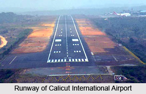
The runway of Calicut International Airport is encircled with hills and valleys. The access funnel area of runway 28 is a 30 to 70-meter deep rolled valley up to a distance of 6000 m, straightaway following the tabletop runway 2860 m long. According to the recommendations of the Directorate General of Civil Aviation, the Airports Authority of India have approved the Calicut International Airport a runway with `lead-in lighting system` for the first time in India. This project costs an estimated rupees 170 lakhs. The `lead-in lighting system` gives a positive visual guidance to the pilot along with a specific approach path. The installation of this system supports the reason of avoiding hazardous terrain, etc.
The system is contrived in such way that `one group of lights is sighted from the preceding group of lights, finally leading the aircraft to the proximity of the threshold of the runway`. At the expanded centerline of the runway of Calicut International Airport, the `lead-in-lighting system` provides a desired approach path. The group of light units are enthroned on top of the 30 m high lattice towers at four locations: 1826 m, 3121 m, 4721 m and 6193 m from the threshold of runway 28. Each group of light consists of three successive flashing lights in linear contour. At each tower locations the lead-in-light units are catered through solar power system with battery banks and inverters. The lead-in-light system is planned along with radio control units for remote operation. The system has been put to service for night operations since 2003. They also have a plan to install the Radio Frequency control for remote operations of the system from ATC tower.


