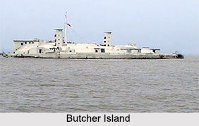
 Butcher Island is an Indian island, located off the coast of the state of Mumbai. More specifically, this island is situated close to Shot Bandar and Elephanta Island. This island is also known by the name of Jawahar Dweep. It is also known to be a restricted area.
Geography of Butcher Island
Globally, the Butcher Island can be pinpointed at coordinates 18 degrees 57 minutes 30 seconds north and 72 degrees 54 minutes 13 seconds east. Mumbai, Dombivli, Kamangaon are the nearby cities of Butcher Island.
Utilization of Butcher Island
Butcher Island functions to serve as an oil terminal. This island has crude oil tanks and a small dock where the oil tankers from Gulf countries are docked to unload crude oil. This crude oil is stored in oil containers on the island. In Mumbai, they are piped to Wadala where they are refined. This helps in preventing any disaster in the city and keeping it safe. Tenders have been invited to develop a second oil terminal. To improve the navigable depths in and around the new terminal, dredging works are currently being undertaken.
Flora of Butcher Island
Most of the Butcher Island is enveloped by dense vegetation. A hillock rises from the centre of the island. It is located about 8.25 kilometres (5.13 mi) from the Gateway of India.
This article is a stub. You can enrich by adding more information to it. Send your Write Up to content@indianetzone.com
Related Articles:
Indian Islands
Indian Mountains
Indian Natural History
Indian Vegetation


