 Borivali Railway Station is a terminus for all slow, semi-fast and fast trains on the Mumbai Suburban Railway system of Maharashtra state. It also serves as the final city-limit stop for all mail and express trains on Western Railway before leaving Mumbai. According to the Right to Information (RTI) Act, Borivali station is the most crowded station with around 2.87 lakhs passengers travelling daily. A large number of commuters from adjoining stations come here to catch a train as it is impossible to board a local train from stations such as Dahisar, Kandivali or Malad.
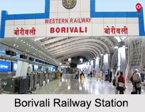
Renovation on Borivalo Railway Station
Inspired by the Swachh Bharat Abhiyan of the Prime Minister Narendra Modi, nearly 500 volunteers formed an NGO called `Making A Difference` (MAD) that have been occupied to keep the station clean and to give it a new look. Ticket windows, pillars, stairs and overhead bridges of Borivali Railway Station have been painted with beautiful colours and representations. The paintings on the ticket booking window and the eastern end have been given the theme of national park and the highway.
New Editions to Borivali Station
Google will be providing high-speed public WiFi service at 100 Railway stations across India by end of the 2018. It has been deploying the service over the extensive fibre network of Indian Railway"s arm Railtel, which provides Internet services as RailWire. Currently, the service is available at 15 stations across the country. Google will also extend the project to cover key suburban Mumbai stations working with RailTel.
Platforms in Borivali Railway Station
From 4th June 2017, after renumbering the platform numbers, here are the platforms that handle the trains:
1st - Caters to Churchgate bound trains
2nd - Caters to Churchgate bound trains
3rd - Caters to both Churchgate bound and Virar bound Trains
4th - Caters predominantly to Churchgate bound trains
5th - Caters to both Churchgate and Virar bound trains
6th - Caters to Virar bound trains and also long distance Express like Rajdhani express and Mail trains going outside Mumbai
7th - Caters to Churchgate bound fast trains and also long distance Express and Mail trains coming into Mumbai
8th - Caters to Churchgate bound trains and also to long distance Express and Mail trains coming into and going outside Mumbai
9th - Caters to Churchgate bound trains and also to long distance Express and Mail trains coming into and going outside Mumbai


