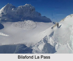
 Bilafond La is a mountain pass with an elevation of 5450 meters. The pass is located on the Saltoro Ridge, which is situated immediately west of the vast Siachen Glacier, some 40 km directly north of map point NJ 980420 which defines the end of the 1972 Line of Control between Pakistan and India as part of the Simla Agreement. The word Bilafond means "pass of the butterflies" in Balti language. Bilafond La pass is on the ancient Silk Route connecting India and China. This pass was a prominent feature during the 1984 military action in the Siachen Conflict between India and Pakistan. The Indian Army captured the pass in 1984 along with Sia La to the north and, in 1987, Gyong La to the south. India currently maintains a strong military base at Bilafond La pass.
Geopolitical Issues on Bilafond La Pass
Bilafond Pass, Sia La pass and Gyong La pass were parts of the military activity of 1984 Operation Meghdoot, which was a part of the Siachen Conflict. Siachen Conflict was a part of the vast Kashmir</b> Conflict. Due to the strategic location of the pass Indian Army maintains a position to defend it.
Visiting Information to Bilafond La Pass
Civilians are usually not allowed to go beyond Panamik, a small village in the Nubra Valley, which is famous for its hot sulphur springs. Annual Siachen civilian trek is organised by the Indian Army, which gives them a chance to trek up to the heights of the glacier, which are covered with ice.
This article is a stub. You can enrich by adding more information to it. Send your Write Up to content@indianetzone.com


