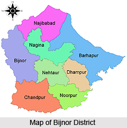
 Bijnor District is located in the state of Uttar Pradesh, India, founded by the Khoye Maurya Gotra Jats. The district headquarters of Bijnor also known as Bijnaur, is situated in Bijnor city. The district is drained and bounded by the Ganga and Ramganga rivers, which also influence the total area of the region. The city of Bijnor has been developing immensely in the past few years and significantly contributes to the economy of the district. There is a sports stadium in Bijnor city that provides opportunities to young talents. Bijnor consists of several state-of the-art healthcare facilties, shopping malls and various educational institutes, which contributes to the overall development of the entire region.
Legends related to Bijnor District
Vidur Kuti, which lies almost 12 km away from Bijnor is of much historical significance. After his dispute with Duryodhana, Mahatma Vidur spent his later years here. According to legends, Lord Krishna had also visited Bijnor. Moreover, during the battle between the Pandavas and Kauravas, Mahatma Vidur is said to have protected and guarded all the women and children family members of both the sides. Due to lack of sufficient area, Vidur decided to have an exclusive area for the women and children. This place is known as Daranagar
According to Abhigyan Shakuntalam, Dushyant, King of Hastinapur reached the area during a hunting session and met with Shakuntala, whom he fell in love with at first sight. The Kanva Ashram, which lies in a ruined state near Rawli town, is believed to be related to this legend.
History of Bijnor District
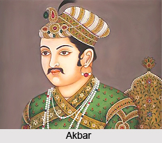
The village of Jahanabad, located 1 km from Ganj on the bank of river Ganga, used to be a Riyasat that consisted of more than 100 villages during Mughal era. Moreover, two Navratnas of Emperor Akbar, Abul-Fazl and his brother Faizi, were born and raised in the region. Najibudaulah`s Fort, located in Najibabad, was established by Gulam Kadir (Najibudaulah) during 18th Century after the collapse of the Mughal dynasty.
Geography of Bijnor District
Bijnor district comprises of the north-west side of the Moradabad Division (Bareilly region) and is an almost triangular elongation of the nation, with its tip pointing towards the north. The western boundary of Bijnor district is created all through by the deep stream of the Ganga River. All the districts of Meerut division, Muzaffarnagar, Dehradun, Meerut and Saharanpur, lie beyond the Ganges.
 The north and north-east lies Garhwal, bounded by the sub-montane road known as Kandi Saradk. This road runs from Hardwar along the foothills of the Himalayas to Haldwani Ramanagar and Tanakpur. River Phika in the east, for the greater part of the Bijnor district, constitutes the border line that segregates Bijnor from Nainital and Moradabad, upto the junction of Ramganga. In the south, the 3 tehsils of Moradabad are situated, namely Amroha, Hasanpur and Thakurdwara.
The geographical coordinates of Bijnor can be mentioned as the extreme parallels of north latitude are 29 degrees 2` and 29 degrees 58` and of east longitude 78 degrees 0` and 78 degrees 57` from Lalitpur to Koti Rao. The distance from Lalitpur to Koti Rao is 90 km, from Koti Rao to Kamharia 92 km and the distance from Kamharia to Lalitpur is around 100 km. The total area of Bijnor District is approximately 4,645 sq km. but it is subject to change due to unpredictable behavior of the Ganga and Ramganga.
Demography of Bijnor District
As per the 2011 census, the population of Bijnor district is 3,683,896 and is ranked 74th out of 640 in India. The population density of Bijnor is 808 people per sq km. over the last decade, from 2001-2011, the population growth rate of the region was 17.64 %. The district has a literacy rate of 70.43 %. Where as, the gender ratio of Bijnor district is 913 females for every 1000 males.
Culture of Bijnor District
The dialect of Western Hindi is the most commonly used language of Bijnor district. The local language has been identified as Rohilkhandi by some experts, but there is no apparent difference in vocabulary or idiom between the vernacular of Bijnor and Hindustani.
Education of Bijnor District
There are several schools, colleges and educational and professional institutes in Bijnor district. The most renowned and established colleges in the region are Jawahar Navodaya Vidhalaya, Krishna College and BIT Institute for Higher and Professional Education.
Administration of Bijnor District
Shri Sanjay Singh Chauhan is the Member of Parliament (MP) of Bijnor district. He is a Gujjar from Muzaffarnagar district and his father was the former Deputy Chief Minister of Uttar Pradesh.
Tourism of Bijnor District
There are several well known and popular tourist destinations in Bijnor district. Vidur Kuti is located 12 km from Bijnor and Ganj is about 12 km from Bijnor city. There are many ancient temples and ashrams in the area. Jahanabad is only 1 km away from Ganj. The temple of Sita, popularly known as Sita Mandir Math, is situated near Nanore Village on Chandpur-Jalilpur road. Sikaida, situated on the Nagina-Bijnor road, is a major tourist attraction of the district. Shakarpuri village, on the Najibabad- Bijnor highway, is also very popular amongst the visitors for its mangoes and sugarcane.
Other renowned tourist destinations in Bijnor district are Bijnor city, Kalheri, Nagina, Chandpur, Sherkot, Ratangarh, Seohara, Najibabad, Sarkara Chakrajmal Village, Dhampur, Askaripur, Kritpur, Seohara, Bahupura, Haldaur, Jhujhaila etc.


