Home > Indian History > Geography of India > Bhrigu Lake
Bhrigu Lake
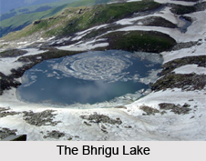
Bhrigu Lake is a high altitude lake located in the Kullu district of Himachal Pradesh.

Share this Article:

Bhrigu Lake, Himachal PradeshBhrigu Lake is located near Manali in Kullu district of Himachal Pradesh. More specifically, it is located to the east of Rohtang Pass. The lake is around 6 kilometres from Gulaba. It is named after Maharishi Bhrigu. Characteristically, this lake is an alpine lake with serene atmosphere around and is also held sacred for its mythical significance. The shallow lake remains frozen for more than half of the year. This lake is one of the prominent tourist attractions of Himachal Pradesh.

History of Bhrigu Lake
History highlights that a sage called Bhrigu of Saptarishi fame used to meditate near this lake. Also, many local Gods of kullu region took a dip in the waters of this lake. For example, guru Vashisht visited this lake at least once in two or three years. Hence, this lake is considered sacred. It is for this reason that the locals believe that this lake never freezes completely.

Geography of Bhrigu Lake
The Bhrigu Lake is located at an elevation of about 4235 metres above mean sea level. Therefore, this lake is at high altitude.

Tourist Attractions of Bhrigu Lake
The Bhrigu Lake serves as a tourism product for Himachal Pradesh, basically in terms of trekking. Several trekking routes lie adjacent to the Bhrigu Lake. The Bhrigu Lake trek route is easily accessible in the upper Kullu valley. Carrying the appropriate trekking equipment, one can experience the virgin forests and lush green meadows on the way. Trekkers can have a bird"s eye view of the surrounding valleys like upper Kullu, Solang and Rohtang. They can also experience the snow clad peaks and ranges of Dhauladhar, Pir Panjal, Great Himalaya and numbers of peak rising above 6000m. Campsite near the lake is also a fun-filled possibility. Nehru Kund, a natural spring of cold water rising from this lake, serves as an attraction of this lake. Apart from the spring, a neatly carved wooden temple, surrounding waterfalls, village home-stays, availability of world cuisines make it a compelling destination for tourists and hikers. The shores of the lake are sparsely populated, which may be an advantage for tourists.

Related Articles:
Lakes of India
Renuka Lake
Dal Lake
Prashar Lake
Rewalsar Lake
Khajjiar Lake
Nako Lake
Gobind Sagar


Share this Article:

Related Articles

More Articles in Geography of India


Geography of Uttar Pradesh
The fourth largest State in India UP is located in the Northern part of India whose area is 2,36,286 sq Kms.
Geography of Maharashtra
Covering an area of 308,000 sq. km, Maharashtra, the third largest state in India.
Geography of Kerala
Geography of Kerala includes plains, hills, valleys and coasts. With the Arabian Sea in the west, the Western Ghats in the east and networked by several rivers, Kerala enjoys diverse geographical features.
Geography of West Bengal
The geography of West Bengal is unique with high peaks of the Himalayan range in the north, the Bay of Bengal in the south and the remaining region is covered with both plains and plateaus.
Geography of Jharkhand
Geography of Jharkhand is comprised of the rich mineral resources and the highly agricultural prospect in this state.
Geography of Sikkim
Geography of Sikkim is characterised by a vast array of magnificent hillock that extends from one corner of the state to the other.
Geography of Meghalaya
The suitable climate, highland plateaus, rivers and the flora and fauna together forms the geography of Meghalaya.
Geography of Mizoram
Mizoram is surrounded by hills, valleys, rivers, waterfalls and lakes. The hills range from 1000 meters to 2000 meters. Rivers, lakes and waterfalls also play major role in forming the land of Mizoram.
Geography of Jammu & Kashmir
Jammu and Kashmir is encompassed by valleys. Some of the dominant valleys of the state are Kashmir Valley, Tawi Valley, Chenab Valley, Poonch Valley, Sind Valley and Lidder Valley etc. Jhelum River is the only major Himalayan River which flows through the Kashmir valley. Indus, Tawi, Ravi and Chenab Rivers are the major ones flowing through the region.
Geography of Daman and Diu
Daman and Diu is situated on the west coast of India and are the smallest union territories of India.
Geography of Goa
Geography of Goa occupies a prime location along the Konkan coastal belt on the western coast of India. The state is bordered by Maharashtra in the north and Karnataka in the south. The Western Ghats in the east contribute to the flora and fauna of Goa.
Geography of Arunachal Pradesh
Geography of Arunachal Pradesh reveals that it is a hilly tract nestled in the foot of Himalayas.
Geography of Kutch
Geography of Kutch District is covering an area of 45,612 km. Kutch District is the largest district in the state of Gujarat.
Geography of Ladakh
Geography of Ladakh mainly comprises the huge Karakoram Range with long stretch of cold desert which mark the region separately from the rest of the states of Indian subcontinent. Surrounded with the mountain ranges from all corners this small region separates Indian subcontinent from rest of the Asian continent.
Geography of Rajasthan
Geography of Rajasthan defines the dry topography with arid climate of the western mountain region.
Geography of Tamil Nadu
The Indian state of Tamil Nadu is located in the Northern hemisphere in the hot zone.