The district is surrounded by Agra and Etawa districts of Uttar Pradesh in the north and Gwalior and Datia districts in the south. The eastern boundary of Bhind is closed by the districts of Etawah Auraiya and Jalaun of Uttar Pradesh, where as the western and north western boundaries of Bhind are common with Morena district. The shape of the district is semi circular, bulging towards the northeast.
The topology of Bhind is the landscape of the valley plains. The plains are closely cultivated and the fields are devoid of trees. Number of rivers and streams flows through the district. The main rivers of the district are Chambal and Sind. The other important rivers of the district are Kunwari, Pahuj, Asan and Vaisali. The soil of the land is fertile. The district is well drained by the Champal and Sind rivers and the tributary streams of the Kunwari and Pahuj.
The climate of Bhind is generally dry except during the southwest monsoon season. The winter is from December to February. It is followed by summer season, which is from March to middle of June. The period from Middle of June to the end of September is the southwest monsoon season. October and November constitutes the post-monsoon season. The average annual rainfall of Bhind is 668.3 mm. There are only 33 rainy days in a year.
After February the temperature increases steadily till May. The heat in summer is intense and the dust laden scorching winds adds to the discomfort of the people. In November, day and night temperature decreases rapidly. January is the coldest month.
History of Bhind
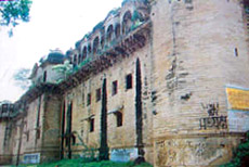 The history of Bhind witnessed the rule of different dynasties as Mauryas, Sungas, Nagas, Hunas Vardhanas, Gujara`s, Kancchapaghatas, Surs, Mughals etc.
Under the Mughals, Bhind formed most part of the Sarkar of Agra in the Subah of Agra. The district comprised the Mahal of Hatkant, which had a brick fort. Until the 18th century, the Mughals ruled the country. The town of Gohad , which is part of Bhind district, was founded by a Jat family.
During the post Mughal Era, Lord Cornwallis I, under another treaty concluded with the Scindhia. The British yielded to Maharaja Daulat Rao Scindia . The History of Bhind District coincides with that of Gwalior tract. Daulat Rao Scindhia died in 1827 and was succeeded by Mugat Rao. He was succeeded by Jayaji Rao.
After the 1857, (Sipoy revolt) Gwalior was attacked by the combined forces of Rani Laxmi Bai Rao Saheb and Tatya Tope. The British then stormed the Gwalior fort and took it on 1858 June 18. It was passed over to the Scindhia in March 1886. On June 1886, Jayaji Rao Scindhia passed away. His son Madhav Rao Scindia succeeded him. The period of his rule is described as one of consolidation and steady progress. After his death on 5th June 1925 he was succeeded by Jiwaji Rao Scindia. It was at his time the Independence movement became strong. JawaharLal Nehru inaugurated the United State of Madhya Bharat, on 28 May 1948 at Gwalior. Bhind was one of the 6 districts of Madhya Bharat.
Economy of Bhind
The economy of Bhind is mainly agriculture. Dairy is the main source of income of the farmers in the district.
Traditional cropping practices along with old conventional tools are still used commonly but the farmers have readily adopted new agricultural machinery as well. The crops cultivated in the Kharif season are soyabean, paddy, cotton, jowar, maize, bajra, pulses, sesamum, and sunflower. During the Rabi season, the crops cultivated are wheat, gram , peas, lahat and toria.
The livestock of the district are cattle, buffalo, sheep, goat, horse, donkey, camel and pigs.
There are about 417 Small Scale Industries in Bhind. About 2340 people are employed in these industries. The incurred establishment expenditure is up to Rs.70 lakhs. Ghee manufacturing in Bhind had been an important industry, along with rearing of livestock for milk and other milk product. The Industrial estate of Bhind is situated at Lahar road, which is 2 km from Bhind town and occupies an area of 10 acres.
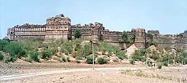 Places of interest in Bhind
•Fort of Ater
•Vankhandeshwar Temple
•The Jain Temples Of Baranso
•Mata Renuka Temple At Jamdara
•Naraddev Temple
•The Fort Of Gohad
