 Bhavnagar Airport is situated in the state of Gujarat, India. It is located on the South-east corner of Gujarat, around 5 km distance from the city centre. Bhavnagar Airport is a domestic airport which has the capacity of 100 passengers per hour for both arrival and departure. This airport was established as a private airport for VIP guests and later on was converted to domestic airport by the airport authority of India. Travel Agents Association of India (TAAI) has given Bhavnagar Airport the award for "Best Domestic Airport".
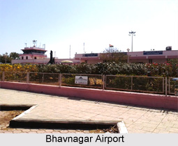
Structure of Bhavnagar Airport
Bhavnagar Airport is perched at a height of 20 ft above sea level and spreads over an area of 294 acres of land. It has only one runway measuring 1,920 m in length, with an orientation of 07/25, and is equipped with Instrument Landing System (ILS) facility. The airport contains two main building, one is domestic terminal that can handle 100 passengers per hour and the other is Air flight control with ILS system. The cargo bay of this airport can accommodate two Boeing 747 planes at a time. This airport provides flights mainly to Mumbai.
Bhavnagar Airport Terminals
Bhavnagar Airport consists of one domestic terminal which is used both for arrival and departure of passengers via domestic flights. Bhavnagar Airport also contains one cargo terminal which is used as a cargo bay for keeping the airplanes and export-import material.
Facilities at Bhavnagar Airport
Baggage services on Bhavnagar Airport are pretty efficient and consist of all new facilities needed for security and safety of the baggage of passengers. Bhavnagar Airport authority has provided so many shops from where one can buy various things like magazines, newspapers and wardrobe. Various eateries are also present on this airport which provides variety of food items to the travellers. There are duty free shops available on Bhavnagar Airport which provides duty free items like sweets and chocolates. These duty free shops make available items to people duty free.
Connectivity of Bhavnagar Airport
Nearest bus stand to Bhavnagar Airport is located at a distance of 8 km. This bus stand is connected via private taxis and state bus services to Bhavnagar Airport. Railway station of Bhavnagar is located at a distance of 9 km from the airport and is directly connected via state bus services and local taxis services.


