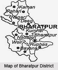
Bharatpur district in Rajasthan is famous for its historical fort and palaces like the Lohagarh fort, Fateh Burj and Jawahar Burj. This district in Rajasthan is also well known for its bird sanctuaries. The history of Bharatpur traces the rise and fall of the Jats in the eastern part of Rajasthan. Under rulers like Badan Singh and Suraj Mai the Jats were active during the late 17th century and served as one of their main centers. The present day Bharatpur has in total 9 Sub Division and ten Tehsils. There are more than 1500 villages which are inhabited.
Location of Bharatpur District
Bharatpur is between 26 degree and 22 minutes to 27 degree 83 minutes North Latitude and 76 degree 53 minutes to 78 degree 17 minutes East Longitude. It is situated 100 meters above the sea level.
 History of Bharatpur District
The `Eastern Gateway of Rajasthan`, was founded by Suraj Mai in 1733AD. Suraj Mai`s first exploit was the capture of Fatehpur fortress (modern day Bharatpur). According to legends, Suraj Mai was blessed by a Naga hermit and, thus, constructed the magnificent fort of Bharatpur in the region formerly known as Mewat. .The untutored genius turned Fatehpur, a small mud-fort into a courage, shrewdness, dogged perseverance and an indomitable never-say-die spirit that would never accept defeat. The place was named Bharatpur after Bharat, the brother of the Hindu mythological Lord Rama. The interesting part of the Bharatpur history is the dominion of Jats in the region since 17th century. They were the first Hindu people with whom the Arabs came into contact and all Hindus were known to the Arabs by the name Jat. The Jats were brought under the same roof and moulded into a force by leaders like Churaman and Badan singh. The Jats cast the final stone bringing about the downfall of the proud and dreaded colossus of Hindustan-the Grand Mughals defeat.
Geography of Bharatpur District
The Northern border of the district touches district Gurgaon of state Haryana, Eastern Border touches district Mathura and Southern border touches Agra district in Uttar Pradesh and Dholpur district of Rajasthan. It touches district of Dausa in south-west and Alwar district in the North-West. Bharatpur state was hemmed in on the west by the Rajput kingdoms; on the north by Delhi and its surrounding districts, and on the northeast by the Marathas, firmly planted in Malwa.
 Culture of Bharatpur District
Bharatpur is referred to as the land of kings; therefore cuisine preparation was very important here. Bharatpur cuisine is highly influenced by the availability of raw material and war-like lifestyle of native inhabitants. The rise of the hotel industry invites visitors coming here. Indian, Continental and regional food of Rajasthan are popular among the visitors. The must have items of Rajasthani food is Dal Bati Churma. Sweets are an integral part of food here, which is served before the starting of food. There are various festivals celebrated in Bharatpur. Brij is celebrated in the month of February and March and Ras Leela is performed during this time. Jaswant Exhibition is being held every year during Dussehra. Gangaur Festival is celebrated in the month of March and April by married women dedicated to Gauri, the incarnation of Goddess Parvati. Teej is celebrated during July and August when the monsoons begin. Bharatpur is the city of the migrants. Except indigenous groups like Tharus, Darai, Kumals and Chepangs, most people have emigrated from different parts of the country. Migration became easy after the eradication of Malaria. The Rapti Valley Development Project, in the sixties, promoted another surge of migration by distributing land. Due to the intermingling of culture there are varieties of castes and ethnic groups which dwell in the municipality. Among them, the Brahmins, Chhetries, Newars, Magars, Tamangs and Gurungs are major ethnic groups. In the downtown of municipality, Newar is the dominant caste. Indigenous tribes such as Chepangs, Tharus, Darais and Kumals can be found in the fringes of the municipality.
Economy of Bharatpur District
 The economy base of Bharatpur is primarily agricultural. The agricultural land is used in both residential area and for industrial purpose. Mostly there are small scale processing industries in Bharatpur. Moreover, this municipality has a substantial volume of poultry products for export trade. Besides, multinational companies are also situated within the municipality. Bee farming is a booming occupation in Bharatpur.
Tourism in Bharatpur District
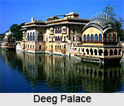
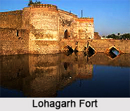
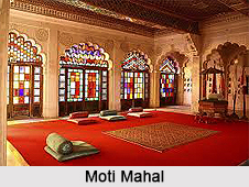
Bharatpur is a major tourist attraction spot. It is synonymous with the picture of wildlife of Rajasthan. This region is popular because of the World Heritage Site, the Keoladeo Ghana National Park. The district of Bharatpur represents yet one more facet of Rajasthan and thereby adds up to the spice of variety. Seeing migratory and non migratory birds at the park is one of the favourite Things to do in Bharatpur. There are also places of historical interest. Deeg palace, for instance, stands majestically over a slightly elevated point. It is surrounded by impressive moats, ramparts and gateways; the interiors are mostly in ruins now, but the watch tower still stands among the ruins, keeping an eye over the city and the palace; over it is placed a gun captured from Agra Fort. Lohagarh Fort, true to its name stood solidly in front of many British attacks. It is very different from the other forts in state, there is no flamboyance associated to fort but it generates an aura of strength and magnificence. Some interesting monuments in the fort are Kishori Mahal, Mahal Khas and Kothi Khas. Moti Mahal and towers like Jawahar Burj and Fateh Burj were erected to commemorate the victory over the Mughals and the British army. The Gateway has paintings of huge elephants. Bharatpur district is well known for its tourist places and as a result people from far of places come here to spend their vacations. With a history dating back to 3500 years it has been a silent spectator to the glory, defeat, romance, separation and several decisions of the ruling class. Though several battles ensued for capturing Bharatpur but eventually it received political stability in the hands of Jats.


