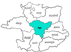
Betul is one of the districts of Madhya Pradesh. The elevation of the district above sea level is 2000 ft. The country is a highland tract that is divided into three distinct portions, differing in their superficial aspects, the character of their soil and their geological formation.. The place occupies nearly the whole width of the satpura range between the valley of the Narmada on the north and the bearer plains on the south. The District extends between 21-22 and 22-24 degrees North Latitude and between 77-10 and 78-33 degrees East. The district is bounded on the north by Hoshangabad, on the south by Amaroti of Maharastra, on the east by Chhindwara District and on the west by the District of Hoshangabad, East Nimar and Amaroti. The District covers and area of 10043 km.
 The climate of the district is fairly healthy. There is a pleasant throughout the greater part of the year. During the cold seasons, at night the thermometer falls below the freezing point. There is no hot wind before the end of April, and even then it ceases after sunset. The nights in the hot season are cool and pleasant. During the monsoon the climate is very damp, and at times even cold.The average annual rainfall is 40 cm.
The major rivers flowing through the district are Ganjal River, Morand River and Tawa River.
Origin of name of Betul
Betul district derives its name from the small town of Betul Bazar about 5Km which is located south of Badnur, the Headquarters of Betul district.
History of Betul
According to history, Betul was the center of Gond kingdoms. In 1398, these kingdoms engrossed all the hills of Gondwana and adjacent countries. In 1418, Sultan Hoshang Shah of Malwa invaded Kherla, and reduced it to a dependency. After nine years the raja rebelled to assert his independence, he was finally subdued and deprived of his territories. In 1467 Kherla was seized by the Bahmani sultan but was afterwards restored to Malwa.
After a century Malwa was incorporated into the dominions of the emperor of Delhi. In 1743 Raghoji Bhonsle the Maratha ruler of Berar, annexed it to his dominions. In 1818, the Marathas ceded this district to the East India Company as payment for a contingent. By the treaty of 1826 it was formally incorporated into the British possessions. The district was then administered as part of the Saugor and Nerbudda Territories. Betul District was part of the province`s Nerbudda Division. Detachments of British troops were stationed at Multai, Betul and Shahpur to cut off the retreat of Appa Sahib, the Maratha general, and a military force was quartered at Betul until June 1862.
Demography of Betul
As per the 2001 census, the population of Betul was 13,95,175. Density of the population is 138/km². The didtrict is rich with tribal people. The tribal population of the district accounts to 5,49,907. Main tribes who inhabit the district are Gonds and Korkus. The other castes are include Rajputs, Kurmis, Kunbis, Bhoyars, Mehras, Chamars and Banias.
Flora of Betul
The main timber species of Betul forest is Teak. The other trees found in abundance are Haldu, Saja, Dhaoda etc. There are also many medicinal plants in the district. The minor forest produce of commercial importance are Tendu leaves, Chironji, Harra and Amla.
