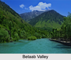
 Betaab valley is situated at a distance of 15 kilometers from Pahalgam in Anantnag district of Jammu and Kashmir. The valley has been named after the Bollywood film "Betaab" starring Sunny Deol and Amrita Singh. The Valley is towards northeast of Pahalgam and falls between Pahalgam and Chandanwadi; it is located on the road to Amarnath Temple Yatra. The valley is encompassed by mountains and covered with dense forests.
History of Betaab Valley
Betaab Valley came into existence during the post geosynclinal stage of the development of the Himalayas. It lies between the two Himalayan Ranges of Pir Panjal and Zanskar. According to the archaeological evidence, human has existed here from the Neolithic Age. Betaab Valley has been ruled by the Mughals since 15th Century. In latter part the Turko-Mughal Military General Mirza Muhammad Haidar Dughlat ruled over Kashmir first on behalf of Sultan Said Khan of Kashgar and then on the behalf of Mughal Emperor Humayun. Later, Sultan Ghiyas-ud-Din Zain-ul-Abidin ruled the entire Kashmir region for about 40 years during which he went on promoting peace and harmony in Kashmir. Under his rule, the social and cultural consciousness of Kashmiri people named "Kashmiriyat" was developed.
Tourism in Betaab Valley
Betab Valley is a popular spot among tourists. It is also serves as a base camp for trekking and further exploration of the mountains. Baisaran and Tulian Lake are the nearby attractions of this place that can also be visited.
Visiting Information to Betaab Valley
Betaab valley is located at a distance of 7.2 km from Pahalgam. So the best way to visit this valley is via Pahalgam. First tourists have to reach Srinagar by either Srinagar Railway Station or Srinagar Airport. Pahalgam should be reached by road from Srinagar; the distance between the two is 92.5 km.
This article is a stub. You can enrich by adding more information to it. Send your Write Up to content@indianetzone.com


