 Banswara District is situated in Rajasthan along the southern-most part of the state. It forms the eastern part of the region known as Vagad or Vagwar. History has it that the district was initially a princely state, ruled by the Maharvals. The name is said to have originated from the name of the Bhil ruler Bansia who ruled over the district. The district of Banswara has a rather rough and rugged topography with the Deccan trap on the eastern part and the Aravalli mountain ranges on the west. Tribals make up the majority of population in the district, and the main groups herein are the Bhils, Bhil Meenas, Damor, Charpotas and Ninamas among others. Banswara is an agriculture-based district with a major portion of the economy depending on the same.
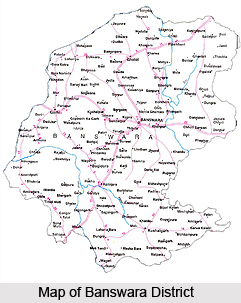
Location of Banswara District
Banswara district is situated in the southern - most part of Rajasthan. It has an area of 5037 square kilometre and lies between 23.11 degrees to 23.56 degrees North latitudes and 73.58 degrees to 74.49 degrees East longitudes. It is bounded on the north by Dhariawad tehsil of Udaipur district and Pratapgarh district; on the east by Ratlam district of Madhya Pradesh; on the west by Sagwara and Aspur tehsils of Dungarpur district; and on the south by Jhabua district of Madhya Pradesh. It also touches the boundary of Panchmahal district of Gujarat on the south-west.
History of Banswara District
The Banswara district forms the eastern part of the region known as Vagad or Vagwar. The district was formerly a princely state ruled by the Maharavals. It is said that a Bhil ruler, Bansia, ruled over it and Banswara was named after his name. Bansia was defeated and killed by Jagmal Singh who became the first Maharaval of the princely state. It is also named so because of the bamboos (Bans) which were found in abundance in the forests. In 1913 some bhils revolted under the headship of a social reformer Govindgiri and Punja which was suppressed in November, 1913. Hundreds of Bhils were shot dead at the Mangarh hillock where they were holding a peaceful meeting. The event is also known as the Mini Jalianwalah Bagh massacre. The place has become sacred and is better known as the Mangarh Dham. With the merger of the princely states in the Union of India, the state of Banswara and Kushalgarh got merged in the Greater Rajasthan in 1949 and Banswara was carved out as a separate district by merging these principalities.
 Geography of Banswara District
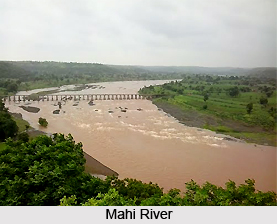
The region represents a rugged terrain undulated by short ridges west of Banswara. The eastern part of it is occupied by flat-topped hills of the Deccan trap. It has the southern end of the Aravalli mountain ranges. The drainage system belongs to the Mahi River which originates from Amjera hills near Dhar in Madhya Pradesh. Its main tributaries are Anas, Chanp, Erav, Haran and Kagdi. The Mahi Bajaj Sagar dam has been constructed on the Mahi, some 16 k.m. away from Banswara town. Right and Left Main Canals and their distributaries irrigate 60,149 hectares of land. Normal annual rainfall is about 82.59 cms. Maize, wheat, cotton, gram are the main crops grown in the district. Graphite, Soapstone, Dolomite, Rock Phosphate, Limestone and a variety of marbles are found here. Gold mineral is also found around Jagpura. Forest land consists of 20 percent of the told area but most of the forest land is devoid of trees.
Administration of Banswara District
Banswara district has three Sub Divisions, Five Tehsils, Two Sub-Tehsils and Eight Development Blocks. Tehsil Banswara and Garhi come under Banswara Sub Division, Tehsil Ghatol is under Ghatol Sub Division and Tehsil Kushalgarh and Bagidora comes under Kushalgarh Sub Division. There are a total of Eight Development Blocks in the district, namely, Anandpuri, Bagidora, Garhi, Ghatol, Kushalgarh, Choti Sarwan, Sajjangarh and Talwara. There are 1503 revenue villages, out of which 1479 are `Abad` and 24 `Gair Abad`, 307 Gram Panchayats, 215 Patwar Mandals and 28 ILR Circles in the district.
People of Banswara District
The district is predominantly inhabited by tribals mainly Bhil tribe, Bhil Meenas, Damor, Charpotas, Ninamas, etc. The district population is 14,20,601 (2001). The rural population is 13, 13,238 (2001) and the urban population is 1, 07,363 (2001). The main occupation of the people, especially of tribals, is agriculture. The tribals live in small one-room houses, known as `tapra`, which lie scattered all over the area. The other major castes are Patels, Rajputs, Brahmin, Mahajans, and Muslims. The dialect spoken in the district is Wagri, a mixture of the Gujarati language and Mewari.
Education in Banswara District
Literacy percentage is 44.63 (2001) but female literacy, though doubled as per 2001 census, is only 28.43 percent. Increase in total literacy percentage has been 18.22 because of the intensive literacy campaign in the district.


