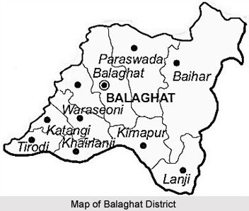
 Balaghat District in Madhya Pradesh looks like a flying bird and is situated in southern part of Jabalpur division. It occupies the southeastern region of the Satpura Mountain Range and Upper Wainganga River Valley.
History of Balaghat District
Balaghat District was constituted during the years 1967-73 by amalgamation of parts of the Bhandara District, Mandla District and Seoni districts. The headquarter of the district was originally called "Burha" or "Boora". Later, however, this name fell into disuse and was replaced by "Balaghat", which was originally the name of the district only. The Wainganga River is the most important river of the district.
Geography of Balaghat District
Balaghat district of Madhya Pradesh spans over a degree from 21.19 degrees to 22.24 degrees North and 79.31 degrees to 81.3 degrees east. The total area of the district is 9245 square kilometres. The Wainganga River separates the district from Seoni while the Bawanthadi River and Bagh River define the inter-state boundary.
The District is very rich in forest wealth. Around 52% of the area is covered with forest. Teak, Sal, Bamboo and Saja are the main trees. Almost 25 years ago, the district was nicknamed as "Hunters Paradise". District is still proud of its varied fauna consisting of Royal Bengal Tiger, Leopard, Bear, Nilgai, deer & bison on one side and birds like Peacock, Red Bulbul and Koyal on the other.
Balaghat district occupies a pride place on the mineral map of India. About 80 percent of the Manganese production of the country comes from Balaghat. The recent discovery of Copper deposit at Malajkhand is regarded as the largest in the country. Over and above this Bauxite, Kyanite and Limestone are the other main minerals of the district.
Demography of Balaghat District
In 2011, Population Census revealed that Balaghat had population of 1,701,156 of which male and female were 841,794 and 859,362 respectively. Balaghat District population constituted 2.34 percent of total population of Madhya Pradesh. The average literacy rate of Balaghat in 2011 was 78.29 compared to 68.72 of 2001.The male and female literacy was 87.13 and 69.71 respectively.
Tourism of Balaghat District
Some of the popular tourist spots of Balaghat District are Part of Kanha National Park, Lanji Fort and Temple, Nahlesara Dam, Rampaily Temple and Gomji-Somji Temple.


