 Bahraich is a beautiful city located at the banks of River Saryu. Bahraich is abounded by myths and legends. It is said that once Bahraich was the Capital of God Brahma, the maker of universe. It was also known as part of Gandharva Forest. It is said that Brahma developed this forest for Rishis & Sadhus as a place of worship.
According to Puranas, King Luv, the Son of God Ram ruled Bahraich. It is said that during the exile, Pandavas, along with their mother Kunti visited this place. Rishi Valmiki, Rishi Balark and Rishi Ashtwakra lived here. Fast flowing rivers and dense green forests add to the beauty of Bahraich.
Origin of name of Bahraich
It is said that Bahraich got its name from Brahma, the maker of the universe. Sources say that there was an ancient Brahma Temple here thus giving the city the name - Brahmaich, thus, Baharich. Others say that the city got its name from the Ashram of Mahirshi Bhar. Once Bahraich was inhabitted by Rishis, Munis(Hindu saints), Bhikhkhus(Bhudhhist Monks).
History of Bahraich
On February 7, Mr. Wingfield was appointed as the commissioner of Bahraich. The agents of leaders of freedom struggle, Nana Saheb & Bahadur Shah Jafa visited Bahraich to have a confidential meeting with local rulers. The meeting was held at a place called "Gullabeer". As part of freedom struggle, mutiny started in Bahraich as soon as it started in Awadh. The struggle at Bahraich was at a large scale. All the people were against the British rule and there was general resentment among the people.
When the struggle started, three British officers moved towards Himalayas via Nanpara. But the soldiers of revolting kings blocked their way and as a result they returned to Bahraich in order to go to Lucknow. But when they reached near Behram Ghat all the boats were under the control of revolting soldiers. Struggle ensued and three officers were killed. Thus the whole district came under the control of freedom fighters.
After the loss of Lucknow, the power of freedom fighters started decaying. On Nov 27, 1857, Balbhadra Singh, king of Chahlari lost his life during the war with britishers near Chinhat. On 26 Dec 1858, British Army captured Nanpara and they ruined the entire place. The freedom fighters gathered at the fort of Bargadia. A great struggle took place there.
Second freedom struggle started in Bahraich with the establishment of congress party in 1920. In 1920, Congress party was established in Bahraich by Baba Yugal Bihari, Shyam Bihari Panday , Murari Lal Gaur & Durga Chand. Smt. Sarojni Naidu visited Bahraich in 1926 and appealed all the workers for self rule and to wear Khadi. In Feb. 1920 total strike was called in Nanpara , Jarwal & Bahraich Town to oppose Simon Commission.
In 1929 Gandhiji visited Bahraich & held a public meeting in old Govt. High School. There were sharp reactions in Bahraich when Gandhiji started his salt movement. On 6th May 1930 there was total Strike. Salt Law was broken. All the eminent leaders of the freedom struggle were arrested.
On 6th October 1931 Pt Jawahar Lal Nehru visited Bahraich & held public meeting at Rampurwa , Hardi, Gilaula & Ikauna. On 9th August when Gandhiji was arrested during Quit India Movement there was great resentment amongst the people and many leaders were arrested.
On 15th Aug. 1947, Gandhiji`s dream became true and the day of freedom was celebrated with great enthusiasm. It is said that 1375 refugees from Pakistan come to Bahraich and were rehabilitated in the district.
Geography of Bahraich
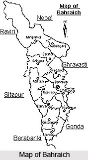
 Bahraich is a city in the Uttar Pradesh state of India. The district is located on the banks of River Saryu, which is a tributary of river Ghaghra. Bahraich is 125 km north-east of Lucknow, which is the state capital of UP. This town acquires importance because it shares an international border with the neighboring country, Nepal. Bahraich is situated between the 28.24 & 27.4 latitude & 81.65 to 81.3 eastern longitude. The area of the district is 4696.8 sq km. Bahraich is bounded by Barabanki & Sitapur in the South , Khiri in the West and Gonda & Srawasti on its east. North of the district is Tarai region which is covered by the dense natural forest.
The main forest areas of Bahraich are Chakia , Sujauli , Nishangara , Mihinpurwa , Bichia & Baghauli. The major rivers of the district are Sarju & Ghaghra. Major part of water is received from rivers & lakes. There are also various lakes and ponds in the city. There is no problem of availability of water in the city as the level of ground water is sufficiently high. Soil is fertile and as a result greenery is spread throughout Bahraich.
The climate of the district is hot and humid. The maximum and minimum temperatures of Bahraich ranges between 44 degree C & 5 degree C. The average rainfall the city gets is 1125 mm.
Politics and Administration of Bahraich
At Bahraich, there are two Parliamentary and eight Legislative Assembly Constituencies. Presently, two of the Legislative Assembly Constituencies of Bhinga & Ikauna are in the newly created district Sravasti. The administration of the district is divided into 4 Tehsils, 12 development blocks, 19 Police Stations, 118 Nyay Panchayats and 776 Gram Sabhas.
Demography of Baraich
As per the 1991 census, the total population of Bahraich is 18, 40, 373. Out of which
9, 97, 512 are males & 8, 42, 861 are females. Rural population of the District is
16, 50, 010 and Urban population is 1, 90, 363. Population of Schedule cast & Schedule tribes are 2, 78, 260 & 6150 respectively. Total Male: Female ratio is 1000:845. Literacy rate of the district is deplorably low. Only 3, 62, 080 of the total population are literate.
Education of Baraich
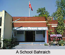
There are totally 2290 schools in Baraich. There are 1889 primary schools, 315 upper primary schools, 39 secondary schools and 47 higher secondary schools. There are no junior colleges and colleges at Baraich.
Economy of Baraich
The economy of Bahraich district is mainly agrarian in nature. 95040 hectares of land of the District is covered by dense forest. Trees like teak, Shisham and Khair are found here. As a result, " kattha" factories are situated in Mihinpurwa block of Baraich. Ideal wood for furniture and buildings work is found here. Fruit trees grown here are mango and guava. The principal crops of the region are wheat, rice, sugarcane, pulse, and mustard. Sericulture is another occupation of the people of the region.
 Bahraich is not industrially developed. Most of the industries in this region are based on agricultural and forest products like sugar mills, rice and daal mills.
Places of interest in Bahraich
The places of interest in Bahraich are:
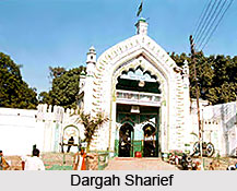
•Dargah Sharief
• Chittaura Jheel
• Temple of Junglee Nath
• Kailashpuri Barrage
• Kartaniya Ghat Alligator Breeding center
