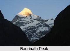
 Badrinath, an Indian peak has exclusively grown up as a Hindu pilgrimage all over the world and also supports township in its deep gorges and valleys. This Hindu holy town has its nagar panchayat in Chamoli district in the state of Uttarakhand, India. It is the most important of the four sites in India`s Char Dham pilgrimage.
The location of Badrinath co-ordinates 30°44?N 79°29?E and 30.73°N 79.48°E. Badrinath Peak has an average elevation of 3,415 metres (11,204 feet). It is included in the Garhwal hills, on the banks of the Alaknanda River. The town lies between the Nar and Narayana mountain ranges and in the shadow of Nilkantha peak (6,560m). Badrinath is located 301km north of Rishikesh. The distance from Gaurikund (near Kedarnath) to Badrinath by road is 233km.
Adi Shankara established Badrinath as a major pilgrimage site in the ninth century. Besides the scenic beauty of Badrinath peak, in recent years its popularity has increased significantly, with an estimated 600,000 pilgrims visiting during the 2006 season, compared to 90,676 in 1961. The temple in Badrinath is also a consecrated pilgrimage site for Vaishnavites.
The name of Badrinath has been mentioned as a holy place in scriptures and legends for thousands of years. According to the Srimad Bhagavatam, there in Badrikashram the personality of Godhead (Vishnu), in his incarnation as the hermits Nara and Narayana, had been undergoing great sacrament since time immemorial for the welfare of all living entities. Badri refers to a berry that was said to grow abundantly in the area, and nath refers to Vishnu. Badri is the Sanskrit name for the Indian Jujube tree, which has an edible, tasty berry. Some scriptural references refer to Jujube trees being abundant in Badrinath. Legend says that the Goddess Lakshmi took the form of the berries to provide nourishment to Lord Vishnu during his long penance in the harsh Himalayan climate.
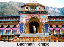
The Badrinath temple on the Badrinath peak is the main attraction in the entire locality. According to legend Shankara discovered a black stone image of Lord Badrinarayan made of Saligram stone in the Alaknanda River. He actually enshrined it in a cave near the Tapt Kund hot springs. In the sixteenth century, the King of Garhwal moved the stone idol to the present temple. The temple on the Badrinath peak has undergone several major renovations because of age and damage by avalanche. In the 17th century, the kings of Garhwal extended the temple. After major damage in the great 1803 Himalayan earthquake, the King of Jaipur rebuilt Badrinath temple.
The Badrinath area around the Badrinath peak is referred to as Badari or Badarikasram in Hindu scriptures. It is a place sacred to Vishnu, particularly in Vishnu`s dual form of Nara-Narayana. One legend has it that when the goddess Ganga was requested to descend to earth to help suffering humanity, the earth was unable to resist the force of her descent. Therefore the mighty Ganga was divided into twelve holy channels, with Alaknanda one of them. It later became the home of Lord Vishnu or Badrinath. The mountains around Badrinath peaks are clearly mentioned in the Mahabharata, when the Pandavas are said to have ended their life by ascending the slopes of a peak in western Garhwal called Swargarohini, literally meaning the `Ascent to Heaven`. Local legend has it that the Pandavas passed through Badrinath and the town of Mana, 4 km north of Badrinath, on their way to Swargarohini.
The area around Badrinath peak was celebrated in Padma Purana as abounding in spiritual treasures. Badrinath has also been praised as Bhu Vaikunta or earthly abode of Lord Vishnu. Many religious scholars such as Ramanujacharya, Madhawacharya and Vedanta Desika went to Badrinath peak and wrote sacred texts, such as commentaries on Brahmasutras and other Upanishads. Located only a few kilometers from the Indo-China (Tibet) border, Badrinath is generally a two-day-long journey from either Kedarnath Mountain, the site that precedes it in the Char Dham circuit, or one of the primary disembarkation points on the plains. Hemkund Sahib, a vital Sikh pilgrimage site, is on the way to Badrinath Peak, so the road is particularly crowded during the summer pilgrimage season. The temple and its substantial surrounding village are accessible by road. The best time to visit Badrinath Mountains is between June and September. Adi Sankara establishes the northern math of Badrinath. Other places in the area are Haridwar and Rishikesh.
The nearest airport to Badrinath is the Jolly Grant Airport near Dehradun, (317 km). The nearest railway stations are at Haridwar (310 km) and Rishikesh(297 km) and Kotdwar, (327 km) respectively. Moreover, there are regular buses operating to Badrinath, from New Delhi, Haridwar and Rishikesh.


