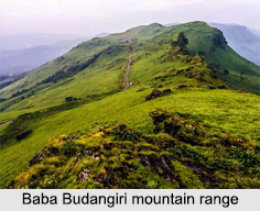
 Baba Budangiri, also known as Dattagiri is a mountain with an altitude of about 1895 m. It is a part of the Baba Budangiri Mountain Range (alternatively called, Dattagiri Hill Range) in the Western Ghats. Baba Budangiri is situated in the district of Chikkamagaluru in Karnataka. Mullayanagiri is another peak in the Baba Budangiri Range. It is the highest peak in Karnataka. Baba Budangiri and Mullayanagiri are jointly called the Chandradrona Parvatha Shreni or the Chandradrona Mountain Range. This is because both the peaks are naturally formed in the shape of a crescent moon. Baba Budangiri is a popular pilgrimage site for both Hindus and Muslims. It attracts several devotees from around the country. It permits trekking and is therefore a popular destination for trekkers.
Shrine of Baba Budangiri
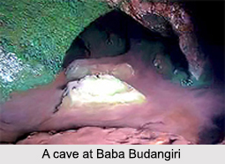
The shrine of Baba Budangiri is dedicated to a 17th century Sufi saint, Baba Budan, who is also known as Guru Dattatreya. He was much venerated by the Muslims. It is believed that the shrine was originally named after Dattatreya, an incarnation of Brahma, Vishnu and Shiva, together known as the Divine Trinity. Dattatreya is considered to be the form of an ascetic of the Avadhuutha discipline. The shrine is situated inside a cave like structure. The origin of the shrine is rooted in many religious beliefs. Most of them are different to each other. It is often said that Baba Budan had taken shelter in the cave for a period, during his visit to India. The shrine is worshipped by both Muslims and Hindus.
Legends Related to Baba Budangiri
According to local legends, Baba Budan carried coffee beans from Yemen and introduced coffee in India. Some legends also highlight that the real name of Baba Budan was Hazrat Shah Jamer Allah Mazarabi, who broke the monopoly of the Arab in coffee trade during the year 1600. While on a pilgrimage to Mecca, Baba Budan visited the Baba Budangiri Mountain Range and planted seven live coffee beans.
 Festivals Celebrated in Baba Budangiri
A few festivals are celebrated in Baba Budangiri like the occasion of Urs , which is the death anniversary of Baba Budan. The festival of Datta Jayanti is also celebrated at Baba Budangiri in the month of December. During Diwali, a beacon is lighted in Baba Budangiri, which is visible even from Chikkamagaluru.
Tourist Destinations near Baba Budangiri
The enthralling landscape and scenery of Baba Budangiri attracts several tourists throughout the year. Seethala situated nearby, has the dual shrine temple of Seethala Mallikarjuna. Three waterfalls namely, Kamana Theertha, Nallikayi Theertha and Gada Theertha are present in the region. They act as popular pilgrimage destinations. Manikyadhara Falls is located on Baba Budangiri Hills near Kemmangundi in Chikkamagaluru district and forms the Nallikayi Theertha. It is almost 40 km from Chikkamagaluru town and almost 4km away from the shrine of Baba Budangiri. Mullayanagiri (around 15 km away from Chikkamagaluru), Sringeri, Ikkeri, Kotebetta, Halebidu, Kundadri Hill, Mallalli Falls, Abbey Falls, Dharmasthala, Sakaleshpur, Kumara Parvata and Bisle Ghat are some of the other renowned tourist destinations near Baba Budangiri. There are also three large caves said to have been sanctified by three Sidddhas. An annual `jatra` (fair) is held here in their honour.
Visiting Information
Baba Budangiri is situated to the north of Chikkamagaluru town and about 270 km away from Bengaluru. The nearest airport to Baba Budangiri is Mangalore International Airport. The nearest railhead to Baba Budangiri is in Shimoga. The roads leading to the mountain area are motorable.


