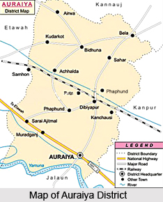
 Auraiya District is an administrative district that lies in the south-western portion of Uttar Pradesh. It is located between 26 degree 21 minutes and 27 degree 1 minute north latitude and 78 degree 45 minutes and 79 degree 45 minutes east longitude. Auraiya District forms a part of the Kanpur Division. This administrative district of Uttar Pradesh is bounded on the north by the district of Kannauj; its western border adjoins tehsil Bharthana of the Etawah district and the district of Gwalior. The eastern frontier marches with the district of Kanpur Dehat, and along the southern boundary lies Jalaun. Auraiya town is the district administrative headquarters.
History of Auraiya District
According to the history of Auraiya District, it was initially formed a part of Etawah District. It was September 17th, 1997; two tehsils of Etawah District namely Auraiya and Bidhuna were carved out for forming Auraiya District. Since, its formation administration has been normal.
Geography of Auraiya District
Topography of Auraiya District includes vast Gangetic plains. It basically includes loamy, clayey and mostly sandy soils. Besides these low-lying beds of clay are found everywhere, these clay beds are known as Jhabar. In the Kurka and trans-Yamuna tract several other types of soils are found. In the ravines of the river and the land immediately adjacent to them are found fields full of gravel, the soil of which is called Pakar; this is in fact a sandy soil mixed with gravel.
 Below the ravines and in the wider valleys between them the soil that is flooded by the Yamuna River is called kachhar; and along the edges of the streams there is a rich strip of alluvial deposit which is known as Tir. Both kachhar and tir vary greatly in quality, some patches of these soils consist of rich reddish clay which lets at a high rental; other portions are composed of a dark coloured loam; and others again are sandy in appearance and less fertile. The district has a humid climate and a year is divided into three seasons - summer, monsoon and winter.
Economy of Auraiya District
Economy of Auraiya District is hugely based on agriculture. Majority of the total population of this district is engaged in agricultural activities. Mainly Rabi and kharif crops are grown in the district. Canals and wells are the main sources of irrigation in the district. Some small scale industries exist in this district of Uttar Pradesh.
Culture of Auraiya District
The language of practically the entire population is what is known as western Hindi. Culture of Auraiya District is really vibrant and colourful. Several popular festivals are celebrated in the district. Like for instance, Durga Puja, Navratri, Holi, Shivaratri, Makar Sankranti, Diwali, Id ul Zuha, Id Ul Fitr, Muharram, etc. are some of the most important celebrations of Auraiya District. About sixty fairs, big and small, are held annually in the district. Most of the festivals are accompanied by local fairs too. Of these, the exhibition and cattle fair of Etawah is the most important. Traditions, beliefs and lifestyle of the people constitute the culture of the region.
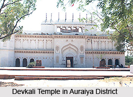
Devkali Temple, Badi Devi Temple and Guraiya Temple are some of the significant holy sites of Auraiya District.


