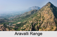
 The Aravalli Ranges are located in the western parts of India, stretching about 300 miles from the northeast to the southwest; the Aravallis intercept the state of Rajasthan on its stretch. Towards the north it continues as a stretch of isolated and rocky ridges that starts in Haryana and ends in Delhi. The south-western range of the Aravalli passes through the states of Gujarat and Rajasthan. The southern slope of the Aravallis is the location of the city of Ajmer. Situated near a narrow gorge, the city of Bundi in Rajasthan is surrounded by the Aravalli Range in the three sides.
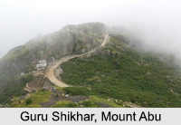
The highest point of the Aravalli range is Guru Shikhar which stands at an elevation of 5,650 ft. It is 15 km from Mount Abu, which is a popular hill station in the Aravalli Range.
Formation of the Aravalli Range
The Aravalli Mountain Range is a northeast-southwest trending orogenic belt in the northwest part of India and is part of the Indian Shield, which was formed from a series of cratonic collisions almost 3500 million years ago. It occupies two-thirds of the southern Indian peninsula. The Aravalli Mountains consist of the Aravalli and Delhi fold belts, and are collectively known as the Aravalli-Delhi orogenic belt. This orogen is an event that leads to a large structural deformation of the Earth`s lithosphere due to the interaction between tectonic plates when a continental plate is crumpled and is pushed upwards to form mountain ranges. The collision between the Bundelkhand craton and the Marwar craton is believed to be the primary mechanism for the development of the mountain range. The Aravalli Mountains are ancient and their existence can be traced back to the Proterozoic Eon. Over time, the mountains have worn down almost completely by millions of years of weathering, where as the Himalayas being young fold mountains are still continuously raising.
Geographical Features of the Aravalli Range
The Aravalli Range can be divided into several parts from the north to south direction. The Archean basement is a branded gneissic complex with medium grade metamorphic and high grade regional metamorphic rocks like schists and gneisses respectively. There are also composite gneiss and quartzites. These form the basement rock for both Delhi Supergroup and Aravalli Supergroup.
The upper Delhi Supergroup overlies on the Aravalli Supergroup with a clear unconformity. This supergroup hosts two main types of rocks. There is a thick sequence of volcanic rocks that is of continental affinity; and sedimentary rocks that represent fluvial and shallow marine environments and deep marine depositional environment. Then in the north Delhi belt, the Delhi Supergroup is classified into 3 groups: lower Raialo Group, middle Alwar Group, and upper Ajabgarh Group. Among other rocks, all the 3 groups consist of mafic volcanic rocks. The Raialo Group consists of calcareous rocks, while the Alwar mainly consists of arenaceous rocks. The Ajabgarh Group is dominated by carbonate and argillaceous rocks.
Within the Delhi Supergroup, the Haryana Aravalli ranges in the west has the Tosham Hill range. Its basement rocks consists of volcanic igneous rocks like the quartz porphyry ring dyke, felsites, welded tuff, quartzite with chiastolite and muscovite biotite granite rocks have commercially nonviable tin, tungsten and copper.
Then there is the Aravalli Supergroup which overlies on top of the Archean basement, forming clear unconformities separating the two strata. The Aravalli Supergroup is divided into 3 groups: lower Delwara Group, middle Debari Group, and Upper Jharol Group. The lower and middle groups shared similar lithology, where both groups are dominated by carbonates, quartzite and peltic rocks, which suggests a shelf depositional environment. In the upper Jharol group, there are turbidite facies and argillaceous rocks, which suggest a deep marine depositional environment.
Climate of the Aravalli Range
In Delhi and Haryana, the Northern Aravalli range has a humid subtropical climate and a hot semi-arid climate with extremely hot summers and cool winters. In Hisar, the main characteristics of the climate are dryness, scanty rainfall and the extremes of temperature. The maximum daytime temperature during the summer varies between 40° C and 46° C. Winters are the coldest, with its temperatures ranging between 2° C and 4° C.
The central Aravalli range in Rajasthan has an arid and dry climate. While, the southern part of the range in Gujarat has a tropical wet and dry climate.
 Rivers flowing through Aravalli Range
The Aravalli Ranges gives rise to several rivers. From north to south, the rivers originate from the western slopes of Aravalli in Rajasthan, pass through the south-eastern portion of the Thar Desert and end into Gujarat. The Luni and Sakhi rivers arise from the north and end their course in the marshy lands of the Rann of Kutch. The Sabarmati River originates from the western slopes of Aravalli of the Udaipur district and end into the Gulf of Cambay of the Arabian Sea.
The rivers flowing from the west to north-west are the Sahibi, Dohan and Krishnavati rivers. The rivers flowing from the west to north-east flow northwards to Yamuna. Here, the rivers are Chambal, Banas, Berach and Ahar rivers. The Wagli, Gambhiri, Wagon and Orai Rivers are the tributaries of the Berach river which flow in this region.
Minerals in the Aravalli Range
The base rocks of Aravalli are of Mewar Gneiss formed by high-grade regional metamorphic processes from pre-existing formations that were originally sedimentary rock with earliest life form that were formed during the Archean eon. Tectonic evolution of the Aravalli Mountains shows Mewar Gneiss rocks are overlain by Delhi Supergroup type of rocks that also have post-Aravalli intrusions. Metal sulphide ores were formed in two different epochs, lead and zinc sulphide ores were formed in the sedimentary rocks during the Paleoproterozoic phase.
The tectonic setting of Zinc-lead-copper sulfides mineralization in Delhi supergroup rocks in Haryana-Delhi were formed in mantle plume volcanic action covering Haryana and Rajasthan during mesoproterozoic. In the southern part of Aravalli Supergroup arc base metal sulphides were generated near the subduction zone on the western fringe and in zones of back-arc extension to the south-east. There is also a commercially viable quantity of minerals such as rock phosphate, asbestos, apatite, kyanite, beryl and deposits of lead-zinc-silver.
Mining in the Aravalli Range
Based on carbon dating, mining of copper and other metals in the Aravalli range dates back to at least the 5th century. Recent research indicates that copper was already mined here during the Sothi-Siswal period. But extensive mining in the Aravallis has led to a negative ecological impact and thus, the Supreme Court of India has laid a ban on mining in the Aravalli region.
Ecology of the Aravalli Range
The Aravalli Range has several forests with a diverse environment and rich wildlife. The first survey that was conducted in the 5 districts of Haryana in the year 2017 was done by the Wildlife Institute of India. There are species of leopards, striped hyenas, golden jackal, nilgai, rhesus macaque, Indian crested porcupine and peafowls.


