 Araria District is an administrative district of Bihar. Araria has been engraved out of the parent district of Purnia. The district covers an area of 2,830 sq km. Araria shares its border with Nepal in the north. Araria is the district headquarters of this administrative district. Araria District is situated at the northern part of Purnia District and Madhepura district in Bihar. Borders of Araria District are surrounded by Nepal in northern side, Kishanganj in eastern side and Supaul at western side. Jogbani is the last point of Araria and after that `Virat Nagar` district of Nepal starts.
History of Araria District
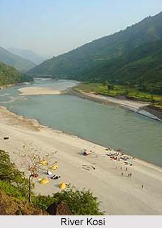
History of Araria District states that this district came into existence in 1990 after the bifurcation of the erstwhile Purnia district. Araria has a very prestigious past though shrouded in midst of uncertainties. References about the history of Araria District are also found in Mahabharata. In ancient times ruled by three important clans of Indian history, Araria may be termed as a place of confluence of three entirely different cultures. The important tribe of Kiratas governed the northern side, while the eastern side was under the Pundras and area west of Kosi River by Angas. They are believed to be the earliest inhabitants of the district, mostly in the area west of the Kosi River and these are among the easternmost tribes as described in the Atharva Samhita known to the Aryans. Pundras are said to be the descendents of Vishwamitra whereas the Kiratas were among the few most important ruling clans of that time. Manu regards the Kiratas as Kshatriyas. Mahadeva was associated with Kiratas and Bhima meets the Kiratas in the east of Mithila, which is the present Araria District. During the Mauryan period this area formed the part of the Mauryan Empire. The district also formed the part of Gupta Empire in India. Due to an impenetrable network of rivers interspersed with large patches of jungle, the area of Muslim control could not extend to the northern portion of the erstwhile Purnia district. Hence the present Araria district seems still to have been held by the hill tribes of Nepal. In the year 1765 though the area came under the Diwani of British East India Company, it was continued to be ruled by the Nawabs of Purnia till 1770. In the year 1864 Araria District was constituted as sub-division by merging the small divisions of Araria, Matiari, Dimia, parts of Haveli and Bahadurganj to provide better administration and ultimately it became a district in 1990.
Demography of Araria District
According to the Population Census in the year 2011, Araria District had a population of 2,806,200 of which male and female were 1,460,878 and 1,345,322 respectively. The population of the Araria District constituted 2.70 percent of total population of Araria District. The average literacy rate of Araria in 2011 was 55.10 compared to 35.01 of 2001. If things are looked out at gender wise, male and female literacy were 64.15 and 45.18 respectively. The total literates in Araria District were 1,235,303 of which male and female were 751,900 and 483,403 respectively. In 2001, Araria District had 589,679 in its district.
Economy of Araria District
Economy of Araria District is dependent on agriculture. The main crops cultivated here are paddy, maize and jute. There are many jute mills in Araria.
Tourism in Araria District
The important places of tourist attraction in Araria are Madanpur, Palasi and Basaithi
Araria is well connected with the other districts of Bihar by bus and railways. The nearest railway station is Araria Court and Araria Railway Station. Araria is also accessible to other parts of India by railways via Katihar.


