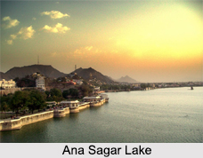
 Ana Sagar Lake is a large artificial lake situated in the city of Ajmer in Rajasthan. Surrounded by some beautiful pavilions and attractive Daulat Bagh gardens, this is one of the most picturesque sights of Ajmer. Ana Sagar Lake was built during 1135-1150 AD by King Anaji Chauhan, grandfather of Prithvi Raj Chauhan, to improvise the civilization of Ajmer. The lake stands as an outstanding land mark of the 11th century which is known for its architecture and scenic beauty. Generally the lake gets dried up during the summer season.
Structure of Ana Sagar Lake
Ana Sagar Lake covers a substantially large area. The lake spreads over an area of 13 km, covering a catchment area which was constructed by the local people of Ajmer. Ana Sagar Lake is mainly known for its location. This lake was constructed by building a dam on the Luni River. It is surrounded with some well maintained and well decorated pavilions which were built by the Mughal Emperor Shah Jahan. This lake is further surrounded by one of the largest gardens of Ajmer. Known as Daulat Bagh, this garden was built by Mughal Emperor Jahangir with few pavilions, which were built out of marble stones. Besides, the lake also includes an island which is located at the centre of the lake. This island is accessible through boats and water scooters.
Surroundings of Ana Sagar Lake
There is a circuit house which is located at the top of the hill on the backdrop of the lake. The circuit house was used as the British Residency in the British era. On the east side of the lake, there is long stretched Daulat Bagh which provides a splendid opportunity for long walks around the lake. All this provide great scenic beauty which is further maintained by the high court that passed orders to ban any type of construction within the catchment area of the lake. The lake is further surrounded with other tourist spots like Adahi-Din-Ka Jhonpra, Taragarh Fort, Nasiyan Temple and Prithviraj Smarak which are equally attractive and entertain the visitors.
Visiting Information to Ana Sagar Lake
The best season to visit the lake is from October to March when the climate remains cool and the lake is filled with water. Nearest airport to reach Ana Sagar Lake is Sanganer Airport in Jaipur, which is 130 km from the lake. Nearest railway station is Ajmer Railway Station which is 1.8 km from the Lake. This place is also well connected to all major cities by bus routes.


