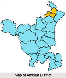
 Ambala is one of the 21 districts of Haryana state. The headquarters of the district is Ambala town. Ambala District lies on the North-Eastern edge of Haryana between 27 degrees 39 minutes to 45 degrees North latitude and 74 degrees 33 minutes to 76 degrees 36 minutes East longitude. It is bounded by the district Yamuna Nagar in the South-East. To its South lies Kurukshetra District, while in its west are situated Patiala and Ropar districts of Punjab and the Union Territory of Chandigarh. The Shivalik Hills of Solan and Sirmaur districts of Himachal Pradesh bound Ambala district in the North and North-East. The average altitude of the district from the sea level is 900 feet approximately. As far the Administration is concerned, it has been divided into two sub-divisions which in turn have been further divided into three tehsils.
History of Ambala District
Ambala District has a rich history. Archaeological evidences suggest that the district has been in existence since the Palaeolithic times. The district of Ambala has also undergone multiple invasions from foreign invaders throughout the ages. It can be said about the district that it had been politically very active in the early ages and also had a strong religious fervour.
Geography of Ambala District
Ambala District has an area of 1568.85 square kilometres. The district is mainly drained by non-perennial streams and the drainage system of the district comprises the Markanda River and its tributaries, the Dangri and its tributaries and the Ghagghar along with its tributaries.

The district of Ambala has a continental in climate. It is very hot in summers and markedly cold in winters. May and June can be really hot with the temperature soaring to over 48 degree Celsius, while in winter it can be as low as -1 degree Celsius. Ambala has a semi-arid as well as tropical climate. Being far away from the coasts and close to the Thar Desert in India, it does not get the full share of the monsoon current.
70 percent rainfall is received during the month of July to September and the remaining rainfall is received during December to February. Ambala is the maximum rain-hit area in Haryana with average rainfall being 47.16 inches per annum.
Administration of Ambala District
The Ambala district consists of three tehsils, namely Ambala, Barara and Naraingarh. To decentralize the authority in the administrative set-up, the district is divided into Sub-divisions, Ambala and Naraingarh. Ambala sub-division was created in 1968. The Naraingarh sub-divisions created in 1956.
Demography of Ambala District
Ambala has a population of 10.13 lacs of persons as per census of 2001. The number of males in Ambala are 5, 42,366 and the number of females are equal to 4, 71,294. The district of Ambala comprises 4.8 percent of the total population of Haryana. The number of literate population of the district are 6, 73,807. More number of males in the district are literate than the number of females. Respectively number of literate males and females are 3, 90,012 and 2, 83,795. The sex ratio in the district is 869:1000. The density of population in the district of Ambala is equal to 644 persons.
Education of Ambala District
There are a number of schools and colleges in the Ambala district. In fact there are several government colleges and post graduate educational institutes in Ambala district. Besides these there are polytechnic colleges, medical colleges, engineering and management institutes as well.


