Aizawl district is amongst the eight districts which belong to the Eastern Indian state of Mizoram. Serchhip district surrounds this Indian district towards the south, Kolasib district surrounds it on its northern end, Champai district on the eastern side and Mamit district on the western side. The total area of Aizawl district measures about 3576.31 square kilometres and the city of Aizawl is the official headquarters of the district of Aizawl.
 History of Aizawl District
Aizawl district has derived its name from Aizawl city, the headquarters of this district. As per the Mizo language, the term `ai` implies a certain herb which belongs to one of the species of turmeric, while `zawl` refers to field or plain. It is believed that Aizawl city obtained its original name probably since it boasted of an abundance of aidu during the ancient times.
Geography of Aizawl District
Aizawl is located on the northern side of the Tropic of Cancer, which is based in the northern portion of the Indian state of Mizoram. It is situated at an altitude of 1132 metres above sea level. Towards the eastern side of this district, the valley of Tuirial river valley is present while towards its western side, the Tlawng river valley is existent. During the summers, the temperature shoots up to about 20 to 30 degree Celsius while in the winter season, the temperature drops to 11 to 21 degree Celsius.
Demographics of Aizawl District
The 2011 census has asserted that the aggregate population of Aizawl district was 4, 00, 309. The literacy rate of Aizawl district was 97.89. The child sex ratio is 979 for 1000 boys according to the 2011 census.
Administration of Aizawl District
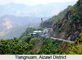
Aizawl district comprises five blocks namely Thingsulthliah, Aibawk, Tlangnuam, Phullen and Darlawn. Aizawl North-I, Aizawl North-II, Aizawl North-III, Aizawl West-I, Aizawl West-II, Aizawl West-III, Aizawl East-I, Aizawl East-II, Aizawl South I, Aizawl South II, Aizawl South III, Tawi, Chalfilh and Tuivawl are the 14 different legislative assembly constituencies.
Aizawl district can be approached from Guwahati and Kolkata with the aide of regular flights, as well as from Imphal by only three flights per week. Lengpui Airport is present about 32 km away from Aizawl.


