 Airports in West Bengal have domestic airports, Air Force Stations as well as an international airport which links it to the global world. Commuting to or from West Bengal is never a problem because the state is well-connected to all the other major states as well as countries domestically and internationally. The domestic airports are handled by Airports Authority of India whereas the Air Force Stations are handled by the Indian Air Force.
The airports list includes international, privately used, domestic and military. Some of the airports of West Bengal are described below:
Netaji Subhas Chandra Bose International Airport
Netaji Subhas Chandra Bose International Airport is located in Kolkata, approximately 17 km (11 mi) from the city center. It is spread over an area of about 2,460 acres (1,000 ha) and serves the Kolkata metropolitan area. It is the fifth busiest airport in India in terms of passenger traffic.
Bagdogra International Airport
Bagdogra International Airport is located about 16 km (9.9 mi) west of the city of Siliguri, about 48 km (30 mi) away from Jalpaiguri and about 65 km (40 mi) away from Darjeeling. Even though Bagdogra Airport is an international airport, it functions as a civil enclave at AFS Bagdogra of the Indian Air Force. The airport is owned by the Indian Air Force. Bagdogra Airport also serves as a gateway airport to the hill stations of Kurseong and Kalimpong and other portions of the North Bengal region.
 Cooch Behar Airport
Cooch Behar Airport is a domestic airport located at Cooch Behar at an elevation of about 138 feet (42 m) above mean sea level. The airport which serves the greater Assam-Bengal border area has one runway designated 04/22, with an asphalt surface measuring 3,500 X 100 feet (1,067 X 30 m) without Instrument Landing System.
Behala Airport
Behala Airport is domestic airport which also serves as a flying school to provide some hands-on training. It is situated in the city of Behala, Kolkata. This airport has one runway with asphalt surface of 1066 m (3500 ft) long with an elevation of 10 m (3 ft) above mean sea level.
Kazi Nazrul Islam Airport
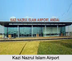
Kazi Nazrul Islam Airport is located at Andal in the district of Paschim Bardhaman. It was officially inaugurated on 19th of September, 2013 and was built over a land of about 650 acres. This domestic airport which is developed and owned by the Bengal Aerotropolis Projects Limited has the distinction of being India"s first Aerotropolis, first privately managed airport and West Bengal"s second largest airport. It serves the industrial cities of Asansol and Durgapur. This airport has a runway of about 2,800-metres in length and an apron with four parking bays and a helipad. The airport also has a CAT I Instrument Landing System (ILS).
Kalaikunda Air Force Station
Kalaikunda Air Force Station is situated near Kharagpur, among the forests of sal in the maoist badlands of West Midnapore. This military airport is owned and handled by the Indian Air Force. It was built by the British for the Royal Indian Air Force during World War II. This airbase has facilities like market, bank, film auditorium, hospital and a school namely, Air Force School, Kalaikunda.
Other Airports in West Bengal
Some of the other Airports in West Bengal are Burnpur Airport, Hasimara Air Force Station, Barrackpore Air Force Station, Air Force Station Salua and Panagarh Air Force Station.


