 The State of Maharashtra is situated in the western part of India. It has the distinction of being the third-largest and the second-most populous state of India. The geographical terrain of this state is characterized by rivers, palm-fringed beaches, islands and mountains. The natural beauty of Maharashtra, along with world heritage sites, temples, national parks and bustling cosmopolitan cities draw tourists to this state. To reach one of the wealthiest and the most developed states in India namely Maharashtra, a number of domestic as well as international airports have been established in the state. Airports are present in almost all the major cities of Maharashtra.
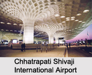
Chhatrapati Shivaji International Airport
Chhatrapati Shivaji International Airport is owned by the Airports Authority of India and operated by Mumbai International Airport Limited (MIAL). It serves as the Mumbai Metropolitan Area. It is formerly known as Sahar International Airport. The passenger traffic at this airport has made it the second busiest airport in India. This airport has five terminals occupying an area of about 750 hectares. Over 780 aircraft movements per day take place at this airport.
Dr. Babasaheb Ambedkar International Airport
Dr. Babasaheb Ambedkar International Airport is located in Sonegaon and serves Nagpur. This customs airport is owned by Airports Authority of India and operated by Mihan India Private Limited. It is named after B. R. Ambedkar, an Indian freedom fighter. It occupies an area of about 1,460-acres.
Baramati Airport
 Baramati Airport is located in the district of Pune. Its airfield occupies an area of about 182.5 hectares and has a height of about 604 meters. The parking capacity of its main apron is 100 m X 75 m. This airport is being utilized for general aviation and pilot training.
Chandrapur Airport
Chandrapur Airport is located about 9 kilometers north-west of Chandrapur in Morwa. The airstrip occupies an area of over 22 hectares and has a height of about 625 feet above mean sea level.
Jalgaon Airport
Jalgaon Airport is located about 6 kilometers south-east of the town of Jalgaon in the Nashik Division. This airport occupies an area of about 630 acres. It has one runway and its new apron can accommodate 2 ATR aircraft at a time.
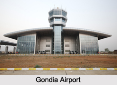
Gondia Airport
Gondia Airport is located near about 12 kilometers north-east of Gondia in Birsi village. This airport is situated at an elevation of about 1,020 feet above mean sea level. Its runway has a length of about 7,515 feet. Gondia Airport is utilized for general aviation and pilot training.
Other Airports in Maharashtra
Kolhapur Airport, Dhule Airport, Aurangabad Airport and Solapur Airport are some of the other Airports in Maharashtra.


