 The state of Himachal Pradesh is located in the northern part of India. This state has convoluted topography of interlocking mountain chains, snowy peaks and plunging river valleys. Such a geographical terrain offers ample opportunity for trekking, rafting, paragliding and skiing. It is for this reason that adventurous tourists are drawn to this state, which is also known as India"s outdoor adventure playground. To reach Himachal Pradesh, a number of airports have been established in the state.
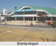
Shimla Airport
 Shimla Airport is situated in Jabarhatti, about 22 kilometers from Shimla. This airport is owned by the Government of India and operated by Airports Authority of India. It was designed by cutting down a mountain top, consequently leveling the region so that the airport"s runway could be laid. The apron of the airport is small and can accommodate two small aircrafts (Dornier Do 228) simultaneously. Its terminal is also small and can accommodate about 50 people in case of arriving flights and 40 passengers in case of departing flights.
Bhuntar Airport
Bhuntar Airport is located in Bhuntar. This public airport is owned by the Government of India and operated by Airports Authority of India. From the perspectives of the pilots, it is a challenge to utilize Bhuntar Airport. The two reasons are its single runway is set in a deep valley whose peaks rise several thousand feet higher than the runway and the location of the airport on the banks of the River Beas. Also in the year 1995, flash floods acted as a threat to the runway of the airport. This airport has been provided with a new air terminal and an expanded apron to enable parking of two aircrafts at a time.
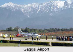
Gaggal Airport
Gaggal Airport is located in Gaggal near Kangra. This military and public airport is operated by the Indian Air Force. It occupies an area of about 1269 acres. Its terminal building has been designed to accommodate about 100 passengers. Its asphalt runway has a length of about 1372 meters and width of about 300 meters. Its apron has parking space to fit 2 turboprop aircrafts like the ATR-72. This airport is also equipped with navigational aids.


