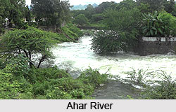
 Ahar River is considered as a significant river in India, since the cradle of Udaipur Civilization was built. Ahar River flows from northwest to southeast in Ahar region through the eastern town of Udaipur. It is a tributary of Berach River, its origins are at the hills of Udaipur District of Rajasthan in western India, and it flows through the city of Udaipur before it joins the Berach. This river is connected to almost every lake and river of Udaipur including Pichola, Bada Madar, Chhota Madar, Bedla River, Govardhan Sagar, Nela Taalab, Roopsagar, Fateh Sagar and Swaroop Sagar. Though ironically, this historically important river is at present functioning as the drainage body of the Udaipur city filled with sewage and garbage. Ahar River is known as the neglected Ganga of the Rajasthan.
Ahar City
Ahar is a small town located at an altitude of 589 meters. Ahar is located in the district of Udaipur in southern region of Rajasthan state. Ahar town is situated 3 km away from Udaipur.
The place is famous for being the cremation ground of the rulers of Mewar. Today, Ahar is also renowned as an archeological site that offers interesting facts to archaeologists and research scholars. Ahar is very popular for an ancient archaeological museum.
Historical Importance of the Ahar City
Ahar region was found by Asaditya about 4000 years. During 1075 AD, Malwa ruler Vikramaditya VI lived in Ahar region before he made Ujjain as the capital of Malwa kingdom. This region was called as Anandpur during the period of Vikramaditya VI. Later on Guhilots took over Anandpur and renamed it as Aharias. Eventually Aharias became a part of Mewar Kingdom and came to be known as Ahar.
A Shiva temple is located on the banks of an artificial reservoir called Gangodbhava Kund. Gangodbhava Kund is an artificial reservoir believed to be sourcing water from the holy Ganges River.
 Banas Culture of Ahar
Culture of Ahar is also known as the Banas culture. This is a Chalcolithic archaeological culture of southeastern Rajasthan. Local Rajasthani folk dances are popular in Ahar.
The people of Ahar use the copper ores of Aravalli range to make artifacts. The archetypal Ahar pottery is a Black and Red ware with dotted and linear designs painted on pots with limited shapes. This pottery art include bowls and lengthened vases. The Ahar culture also had Red Ware, Grey ware and ceramic wares etc.
Connectivity to Ahar
Dabok airport also known as Maharana Pratap Airport is 20km from Ahar town. Taxis are available to Ahar town from Dabok which is the only means of transport to and from the airport. Nearest rail head is Udaipur. Udaipur is well connected to other parts of Rajasthan state as well as other states of India. Ahar is situated on NH-8. Ahar is closer to Udaipur and is well connected with major cities of Rajasthan by buses. From Udaipur Taxis, private buses and shared autos too ply on a regular basis to the Ahar.
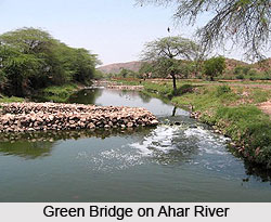
Green Bridge on Ahar River
The Green Bridge technology, however, proved a life saving measure. It was initiated by Jheel Sanrakshan Samiti (Lake Conservation Society) in 2009. The project was completed in 2010.
The installation of Green Bridge was done at one end of Ahar River, the point where the river enters the Udaisagar Lake. 6 bridges of varying length were installed. 2 screens made up of mild steel were installed to prevent floating objects. All floatable and suspended solids like cans, bottles and other wastes were trapped in this biological bridge.


