Home > Indian History > Geography of India > Agatti Island
Agatti Island
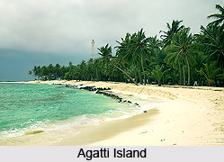
Agatti Island is located in Lakshadweep and it served as the leisure tourism destination. It also served as the communication centre with other islands of Lakshadweep.

Share this Article:

Agatti Island, LakshadweepAgatti Island which is also known as Agathy is an ideal tourist destination among the local, national and foreign travellers. This island acts as a leisure tourism site in Lakshadweep Islands.

Agatti Island is a 5.6 km long island. It is located about 459 kilometres off Kochi, which is termed as a major sea port in the mainland India and 7 kilometres to the southwest of Bangaram Island, the nearest island to Agatti Islands. Agatti Islands which is also known as Agathy is the perfect place to stay a weekend or having a honeymoon visit.

Agatti Island is 531 kilometres away from Kollam Beach (Quilon Beach) and 529 kilometres away from Kollam Port. Kavaratti, the capital Island of Lakshadweep Group of Island and the closest inhabited island of Lakshadweep, lies 54 kilometres to the South East part and the uninhabited Suheli Par atoll 76 kilometres to the south. The total land area of Agatti Island is approximately 2.7 square kilometres. The small island of Kalpati is located at the southern end on the same reef.

Agatti Island has a population of 5,667. It was according to 2001 census. All the inhabitants of Agatti Islands belong from Muslim religious community which is said to have been brought by Arab traveller Ibn Batuta. Most people speak in Malayalam language and English language. Agatti Island has its own 100 KW power house which uses fuel to generate electricity. There is a Sea Water Desalination unit which provides desalinated water to the islanders.

Agatti Island is easily accessible by sea routes and air routes. Agatti Aerodrome requires a 24 hour voyage by ship and the flight time range from Kochi is 75 minutes. Agatti Aerodrome is the only airport in Lakshadweep.

Agatti Island is one of the Lakshadweep islands which is open to tourism. The visitors, however, are allowed to enter in Agatti Island under certain restrictions. They are required to obtain Entry Permit from the Lakshadweep Administration for entering or visiting the island. Entry Permit is issued based on the visitor having a confirmed place to stay. A bike or bicycle ride in the sea beach of Agatti Island will be the perfect gift for tourists.


Share this Article:

Related Articles

More Articles in Geography of India


Geography of Uttar Pradesh
The fourth largest State in India UP is located in the Northern part of India whose area is 2,36,286 sq Kms.
Geography of Maharashtra
Covering an area of 308,000 sq. km, Maharashtra, the third largest state in India.
Geography of Kerala
Geography of Kerala includes plains, hills, valleys and coasts. With the Arabian Sea in the west, the Western Ghats in the east and networked by several rivers, Kerala enjoys diverse geographical features.
Geography of West Bengal
The geography of West Bengal is unique with high peaks of the Himalayan range in the north, the Bay of Bengal in the south and the remaining region is covered with both plains and plateaus.
Geography of Jharkhand
Geography of Jharkhand is comprised of the rich mineral resources and the highly agricultural prospect in this state.
Geography of Sikkim
Geography of Sikkim is characterised by a vast array of magnificent hillock that extends from one corner of the state to the other.
Geography of Meghalaya
The suitable climate, highland plateaus, rivers and the flora and fauna together forms the geography of Meghalaya.
Geography of Mizoram
Mizoram is surrounded by hills, valleys, rivers, waterfalls and lakes. The hills range from 1000 meters to 2000 meters. Rivers, lakes and waterfalls also play major role in forming the land of Mizoram.
Geography of Jammu & Kashmir
Jammu and Kashmir is encompassed by valleys. Some of the dominant valleys of the state are Kashmir Valley, Tawi Valley, Chenab Valley, Poonch Valley, Sind Valley and Lidder Valley etc. Jhelum River is the only major Himalayan River which flows through the Kashmir valley. Indus, Tawi, Ravi and Chenab Rivers are the major ones flowing through the region.
Geography of Daman and Diu
Daman and Diu is situated on the west coast of India and are the smallest union territories of India.
Geography of Goa
Geography of Goa occupies a prime location along the Konkan coastal belt on the western coast of India. The state is bordered by Maharashtra in the north and Karnataka in the south. The Western Ghats in the east contribute to the flora and fauna of Goa.
Geography of Arunachal Pradesh
Geography of Arunachal Pradesh reveals that it is a hilly tract nestled in the foot of Himalayas.
Geography of Kutch
Geography of Kutch District is covering an area of 45,612 km. Kutch District is the largest district in the state of Gujarat.
Geography of Ladakh
Geography of Ladakh mainly comprises the huge Karakoram Range with long stretch of cold desert which mark the region separately from the rest of the states of Indian subcontinent. Surrounded with the mountain ranges from all corners this small region separates Indian subcontinent from rest of the Asian continent.
Geography of Rajasthan
Geography of Rajasthan defines the dry topography with arid climate of the western mountain region.
Geography of Tamil Nadu
The Indian state of Tamil Nadu is located in the Northern hemisphere in the hot zone.