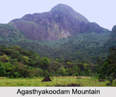
 Standing at an elevation of 1, 868 m, the Agasthyakoodam Mountain is one of the tallest peaks of the Pothigai Mountain range of the state of Tamil Nadu. The peak lies on the border of the states of Tamil Nadu and Kerala and is part of the Agasthyamala Biosphere Reserve. The Agasthyakoodam Mountain is located within the Neyyar Wildlife Sanctuary in the Western Ghats.
Geography of Agasthyakoodam Mountain
The Agasthyakoodam Mountain is in close proximity to the Neyyar Dam, the base camp of Bonacaud and the hill station of Ponmudi. The Kalakkad Mundanthural Tiger Reserve is also a part of the mountain range and part of the peak can be seen from the upper Kodyar region.
From the eastern slope of the mountain, it is the origination point of the perennial Thamirabarani River, which flows into the Tirunelveli district of Tamil Nadu. Other major rivers that originate from the Agasthyakoodam Mountain are the Neyyar River and Karmana River, both of which flows through the Thiruvanathapuram district and the latter is a major source of drinking water to the city.
Trekking in Agasthyakoodam Mountain
The only way to reach the peak of the Agasthyakoodam Mountain is by trekking, which is allowed in the region but based on strict guidelines. From the months of January to mid March, the area is open for pilgrims to trek. The trekking passes are issued by Kerala Forest Department from the district office at Thiruvanathapuram.
The trekking route starts from Bonacaud, which is about 20 km away from the peak and requires about two days reaching the peak from Bonacaud. On the way up, the trekkers witness the rich flora and fauna of the Agasthyamala Biosphere Reserve. At the base stations of the mountain at Brimore, Bonacaud, and Ponmudi, the trekkers get to see the first tea gardens that were established by the British.
Earlier women were forbidden to trek the mountain but after a court ruling which removed the prohibition, a woman named Dhanya Sanal, reached the peak in 2019, becoming the first woman known to make the climb. Since the change in the law, more than 100 other women have registered for a license to make the climb.
Religious Aspect of Agasthyakoodam Mountain
Named after the Hindu sage Agastya, one of the Saptarishis of Hindu Puranas, the Agasthyakoodam Mountain is an important pilgrimage centre among the devotees of the sage. As per Tamil traditions, sage Agastya compiled the Agattiyam, which is the first Tamil grammar and thus he is considered to be the father of Tamil language. He is also known to be the creator of the Malayalam language. Atop the Agasthyakoodam Mountain, there is a small stone statue of sage Agastya, where the devotees themselves can offer prayers.
Manjolai Hills of Agasthyakoodam Mountain
Located atop the Manimuthar Dam and the Manimuthar Waterfalls, the Manjolai area is set deep within the Western Ghats in the Kalakkad Mundanthurai Tiger Reserve in Tirunelveli District. The area is famous for its tea plantations and the small settlements surrounding it, the Upper Kodaiyar Dam, and a windy view point called Kuthiravetti. It is an important area of the Agasthyakoodam Mountain that is often visited by tourists.
Visiting Information on Agasthyakoodam Mountain
The major city and airport nearest to Agasthyakoodam is Thiruvananthapuram and its Trivandrum International Airport around 61 km away. The nearest railway stations are Thiruvanathapuram, Kerala and Ambasamudram.


