Home > Indian History > Geography of India > Dargah Sharif of Peer Hazrat Shah Kamal Baba
Dargah Sharif of Peer Hazrat Shah Kamal Baba
Dargah Sharif of Peer Hazrat Shah Kamal Baba is a popular dargah which stands right at the Indo-Bangladesh border in West Garo Hills, Meghalaya.

Share this Article:

Dargah Sharif of Peer Hazrat Shah Kamal Baba, Garo Hills, Meghalaya
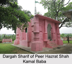
Dargah Sharif of Peer Hazrat Shah Kamal Baba in Meghalaya is popularly known as Peersthan or Dargah which has been a symbol of communal harmony since centuries. The site is the burial place of the last remains of Hazrat Shah Kamal and his Garo wife. The Peersthan is also known for the presence of a stone believed to be of Devi Kamakshya of Mankachar, Assam. The structure of the shrine represents similarity to the Mughal architecture. Dargah Sharif of Peer Hazrat Shah Kamal Baba is presently being maintained by the Fakir Sawayat worshippers.

Location of Dargah Sharif of Peer Hazrat Shah Kamal Baba
Dargah Sharif of Peer Hazrat Shah Kamal Baba is located in West Garo Hills, Meghalaya. It is about 80 kms from Tura, near India-Bangladesh border.

History of Dargah Sharif of Peer Hazrat Shah Kamal Baba
The history behind this Dargah Sharif of Peer Hazrat Shah Kamal Baba dates back to about 700 years during the reign of Raja Mahendranarayan. Legend has it that during the rule of Raja Mahendra Narayan - the Zamindar of Karaibari, a demon was creating destruction by killing and devouring the people of the village. Shah Kamal by his super natural power drove away the demon and restored peace in the kingdom. The Raja as a token of his gratitude donated 1280 bighas of land as a gift to Shah Kamal. After the death of Shah Kamal and his wife, the burial place was constructed on a hillock overlooking Bangladesh and till today the graves of the couple can be seen in this Dargah.

Celebration at Dargah Sharif of Peer Hazrat Shah Kamal Baba
Dargah Sharif of Peer Hazrat Shah Kamal Baba is also characterized by a continuous traditional annual Urs or the prayer-fair that has existed since the pre-partition of East Bengal and held at the Peersthan, close to Mahendraganj, West Garo Hills. Every year Muslims, Hindus and Garos irrespective of caste, creed and religion, assemble to celebrate the occasion as an annual Mela. People from across the state and neighbouring states pour in hundreds to seek blessings from the Peer Baba at his shrine.


Share this Article:

Related Articles

More Articles in Geography of India


Geography of Uttar Pradesh
The fourth largest State in India UP is located in the Northern part of India whose area is 2,36,286 sq Kms.
Geography of Maharashtra
Covering an area of 308,000 sq. km, Maharashtra, the third largest state in India.
Geography of Kerala
Geography of Kerala includes plains, hills, valleys and coasts. With the Arabian Sea in the west, the Western Ghats in the east and networked by several rivers, Kerala enjoys diverse geographical features.
Geography of West Bengal
The geography of West Bengal is unique with high peaks of the Himalayan range in the north, the Bay of Bengal in the south and the remaining region is covered with both plains and plateaus.
Geography of Jharkhand
Geography of Jharkhand is comprised of the rich mineral resources and the highly agricultural prospect in this state.
Geography of Sikkim
Geography of Sikkim is characterised by a vast array of magnificent hillock that extends from one corner of the state to the other.
Geography of Meghalaya
The suitable climate, highland plateaus, rivers and the flora and fauna together forms the geography of Meghalaya.
Geography of Mizoram
Mizoram is surrounded by hills, valleys, rivers, waterfalls and lakes. The hills range from 1000 meters to 2000 meters. Rivers, lakes and waterfalls also play major role in forming the land of Mizoram.
Geography of Jammu & Kashmir
Jammu and Kashmir is encompassed by valleys. Some of the dominant valleys of the state are Kashmir Valley, Tawi Valley, Chenab Valley, Poonch Valley, Sind Valley and Lidder Valley etc. Jhelum River is the only major Himalayan River which flows through the Kashmir valley. Indus, Tawi, Ravi and Chenab Rivers are the major ones flowing through the region.
Geography of Daman and Diu
Daman and Diu is situated on the west coast of India and are the smallest union territories of India.
Geography of Goa
Geography of Goa occupies a prime location along the Konkan coastal belt on the western coast of India. The state is bordered by Maharashtra in the north and Karnataka in the south. The Western Ghats in the east contribute to the flora and fauna of Goa.
Geography of Arunachal Pradesh
Geography of Arunachal Pradesh reveals that it is a hilly tract nestled in the foot of Himalayas.
Geography of Kutch
Geography of Kutch District is covering an area of 45,612 km. Kutch District is the largest district in the state of Gujarat.
Geography of Ladakh
Geography of Ladakh mainly comprises the huge Karakoram Range with long stretch of cold desert which mark the region separately from the rest of the states of Indian subcontinent. Surrounded with the mountain ranges from all corners this small region separates Indian subcontinent from rest of the Asian continent.
Geography of Rajasthan
Geography of Rajasthan defines the dry topography with arid climate of the western mountain region.
Geography of Tamil Nadu
The Indian state of Tamil Nadu is located in the Northern hemisphere in the hot zone.