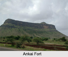
 Located in western India on the Satmala Range hills, the Ankai Fort is situated in Nashik district in the state of Maharashtra. This historical fort standing tall at an average height of 3,170 ft atop the hills is located with perpendicular scraps on all sides, except for a narrow nose on the eastern side.
History of Ankai Fort
It is said that the Yadava of Devagiri had built the Ankai Fort but was captured by Shah Jahan"s general Khan Khanan in 1635. In the notes of French traveller, Thevenot, he mentions the Ankai Fort as a stage between the cities of Surat and Aurangabad. After the Mughals, the Ankai Fort was captured by the Nizam and in 1752; it came under the Maratha Empire after the Treaty of Bhalki. Finally in 1818, the fort came under the administration of the British Empire. Currently, the Ankai Fort is under the governance of the Government of India.
Surrounding the fort are some popular places like the Brahmani and Jain caves, the Manmad Gate, and the Kashi Pond among others, which are popular places of attraction. Other than this there is also a series of rock cut water cisterns on the southern side of the fort.
Visiting Information on Ankai Fort
The Ankai Fort is about 97 km away from Nashik and the nearest railway station is in Nashik at a distance of 98 km. The Nashik Airport is the closest at about 81 km from the fort.
This article is a stub. You can enrich by adding more information to it. Send your Write Up to content@indianetzone.com.
