 The state of Kerala is located in the southern part of India, more specifically, on the Malabar Coast. National Geographic`s Traveler Magazine labeled Kerala as one of the "ten paradises of the world" in the year 2012. Kerala`s beaches, backwaters, lakes, mountains, hills, waterfalls, museums, ancient ports and religious institutions have lent beauty and popularity to this state. Apart from the above mentioned attractions, Kerala also has a number of islands. Some of them are described below.
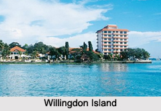
Willingdon Island
Willingdon Island is a part of the city of Kochi. It has the distinction of being the largest man-made island in India and was established using the sand dug out while deepening the Kochi port. The name of this island has been derived from the name of the former Madras governor, Lord Willingdon. This island houses the port of Kochi, Kochi Naval Base of the Indian Navy, Central Institute of Fisheries Technology, etc.
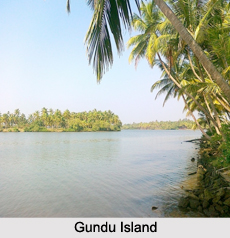
Gundu Island
Gundu Island became a part of Kochi on the basis of the November, 1967 amalgamation order of the Kerala Legislative Assembly. The area of 5 acres (20,000square meters) has made it the smallest island around Kochi. Features of this island which help in drawing tourists are cool breeze and its calm atmosphere. This island is adorned with coconut trees, which completely surround it.
Ezhumanthuruthu
 Ezhumanthuruthu is a small island situated in Kottayam district. It also has a twin island namely, Pulithuruthu. Most of the people living on this island are agricultural laborers and small or medium farmers. This island is growing as a tourism product of Kaduthuruthy Grama Panchayath. This island is reflecting it"s suitability for "monsoon tourism" and "inland water tourism". Government of Kerala aims to deepen the river extending towards Vaikom, in order to draw more foreign tourists.
Pathiramanal
Pathiramanal is a small island on the Vembanad Lake in Muhamma Panchayat of Alappuzha district. This island is spread over 28.505 ha. This island provides opportunity for bird sighting. This island has about 91 local birds and 50 migratory birds.
Moolampilly
Moolampilly is an island near Kochi. Its handmade earthen pots and tandoori ovens have lent popularity to this island.
Kothad
River Periyar surrounds an island called Kothad in Ernakulam district. Paddy fields cover 70% of this island. Higher Secondary School of Jesus testifies to the development of education in Kothad. Christianity and Hinduism are the two religions mostly followed on this island. Kothad houses the popular Sacred Heart Church and a number of temples.
Other Islands of Kerala
Sathar Island, Nedungad, Kuruvadweep, Pulinkunnoo and Venduruthy are some of the other Islands of Kerala.


