 The state of Chhattisgarh is a part of central India. This state has waterfalls, temples, caves, rock paintings, monuments, rare wildlife, national parks, wildlife sanctuaries, archaeological sites, etc which draw a plethora of tourists here. To reach Chhattisgarh, a number of airports have been established in the state.
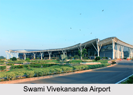
Swami Vivekananda Airport
Swami Vivekananda Airport is located in Ramchandi in Raipur. This primary airport of Chhattisgarh is owned by the Government of India and operated by the Airports Authority of India. It has been provided with a new integrated terminal covering an area of about 18,500 square meters. It has night landing facilities, a CAT- 1 Instrument Landing System and navigational facilities. It was recognized by the Union Tourism Ministry as the Best Airport of the Country for the year 2013 in Non-Metro Category.
Bilaspur Airport
Bilaspur Airport is located in the village of Chakarbhatta, about 10 km south of Bilaspur. This public airport is owned and operated by the Airports Authority of India. This airfield has an elevation of about 276 meters above mean sea level. It has been provided with a runway 17/35. It has a length of about 1535 meters and width of about 25 meters with turning pads at both ends. The runway is linked to a small helipad cum apron via a 630 meter long taxiway.
Bilaspur Airport is presently being utilized for general aviation and training of pilots. But the Indian Army desires to take this airport under its control and set up a facility for training of special forces. In response to the demands of the Indian Army, Airports Authority of India has made a "conditional offer" of retaining about 56 acres for a civil enclave and parting with a land of about 377 acres.
Jagdalpur Airport
Jagdalpur Airport is situated near Jagdalpur. This airport is operated by the Airports Authority of India. It has an elevation of about 1,822 ft (555 meters) above mean sea level. Its asphalt surfaced runway has a length of about 1,707 ft (5,600 meters). Jagdalpur Airport was chosen for upgradation as a result of the state government`s efforts to provide industrially wealthy areas of the state with enhanced air services. With the development of Jagdalpur Airport, it will get promoted to 2C category, which would enable operations of 40-50 seats ATRs.
Raigarh Airport
Raigarh Airport is located near Kondatarai, about 9 km south of Raigarh. This public airport is operated by the Airports Authority of India and is utilized by small aircrafts and choppers.
OP Jindal Airport
OP Jindal Airport is a private airport located in Raigarh.


