 The state of Jharkhand is located in the eastern part of India. The geographical terrain of this state is characterized by Chota Nagpur Plateau, lush green hills, waterfalls and forests (covering 29.61% of the state). These, along with the state"s flora and fauna, fairs and festivals, temples, museums, rich mineral wealth and diverse culture draw a plethora of tourists here. To reach this "land of forest" namely, Jharkhand a number of airports have been established in the state.
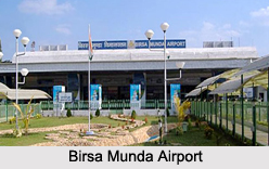
Birsa Munda Airport
Birsa Munda Airport is located in Hinoo in Ranchi. This domestic airport is operated by Airports Authority of India and is named after Birsa Munda, an Indian tribal freedom fighter. It is the 37th busiest airport in India. This airport has been provided with only one integrated terminal. It has facilities for travel desks, lounges, etc. The departure side of the airport has been provided with aerobridges. In the past 3 years, this airport has experienced growth which is evident from various budget airlines adding it to their route.
Bokaro Airport
Bokaro Airport is situated in Bokaro Steel City on National Highway-23 or Bokaro-Chas Road. This private airport is operated by Steel Authority of India Limited (SAIL). It has been provided with one paved runway which is asphalt-surfaced, designated 13/31 and oriented by measures of 5,300 ft in length. According to the analysis of the National Highway Authority of India (NHAI), the length of this airstrip was suggested to be increased by another 700 feet to a total of 6,000 feet, in order to permit landing of larger aircrafts.
Sonari Airport
Sonari Airport is located in Jamshedpur. This public airport is operated by TATA Steel. The airport receives unscheduled chartered flights from Kolkata. It occupies about 25 acres of land.
Dhanbad Airport
Dhanbad Airport is located in Dhanbad, alongside the Grand Trunk Road at Barwadda. This public airport is owned by the Government of Jharkhand. The new passenger waiting hall of this airport was inaugurated by the then chief minister of Jharkhand namely, Shibu Soren in October, 2008.
Chakulia Airport
Chakulia Airport is located southwest of the city of Chakulia in Purbi Singhbhum district. It was constructed by a British Construction Contractor namely, Mr. Digar Pramotha Nath Mohanty to carry out raids against the advancing Japanese in Burma and also to transport some sort of aid to parts of China. It is known that since World War II, this airfield has been dysfunctional.


