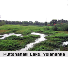
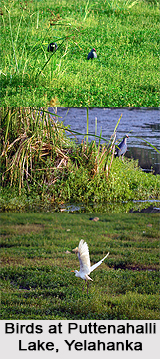
 Puttenahalli Lake, also referred to as Yelahanka Puttenahalli Lake, is a 10-hectare natural water body near Yelahanka, a suburb in the northern part of the capital city of Bengaluru, in the state of Karnataka. The lake is primarily popular for being an excellent bird watching destination. It should not be confused with the more popular Puttenahalli Lake in J. P. Nagar, which is located in the southern part of Bengaluru city.
Location and Area of Puttenahalli Lake, Yelahanka
Puttenahalli Lake is situated on Doddaballapur Road near Yelahanka, 14 kilometres north of the capital city of Bengaluru. Situated near a suburb, the natural landscape and isolated environment attracts a number of local and migratory birds.
The Yelahanka Puttenahalli Lake expands over an area of about 25 acres (0.1 square kilometres).
Avifaunal Attractions in Puttenahalli Lake, Yelahanka
The Yelahanka Puttenahalli Lake is a paradise for bird watchers. A myriad range of bird species inhabit the region.
49 bird species have been discovered breeding here. These include Darters, Painted storks, Black-crowned Night Herons, Purple Herons, Pond Herons, Egrets, Asian Openbill Storks, Eurasian Spoonbills, Spot-billed Pelican, Little Grebe, Little Cormorant, Spot-billed Ducks, Purple Moorhen, Common Sandpiper and other water birds.
The lake is prominent for being a bird-watching site, besides also being a serene and recreational natural spot for its visitors. More than 7,000 birds can be sighted during the breeding season and the avifauna also includes some of the endangered and migratory birds from the Northern Himalayas and Siberia. Many species which are listed under threatened category of the International Union for Conservation of Nature (IUCN), find the lake as their preferred habitat during the breeding season.
On a normal day, neighbourhood residents can be seen walking and occasionally the bird watching enthusiasts and photographers are seen with their equipment near the lake during early mornings when the birds fly out from their nests spreading their wings. The surrounding trees get adorned with the winged creatures perching on them. The lake has watch towers, trekking paths, guides to identify birds for tourists and other basic facilities.
 Protection and Conservation of Puttenahalli Lake, Yelahanka
The lake along with a plant nursery housing many trees is managed by the Forest Department. According to the Principal Chief Conservator of Forests (Wildlife) Avani Kumar Varma, steps are being taken to designate the lake water body as a protected area. Earlier, the lake was under the Lake Development Authority (LDA) and was listed for further development for commercial purposes under public-private partnership model. The state government later approved of withdrawing the lake from the LDA and the lake is in the process of being declared as a conservation reserve. As a conservation reserve, the rich bird population of the lake, which is so rare in an urban setting, will be preserved. Eight residents from the neighbourhood too have started a trust called Yelahanka Puttenahalli Lake & Bird Conservation Trust, to protect the birds and work towards enriching the biodiversity in the lake. The government and the trust are working together towards making the lake a biodiversity spot and convert it into a Bird Reserve.
Visiting Information to Puttenahalli Lake, Yelahanka
The Puttenahalli Lake in Yelahanka can be accessed by all convenient means.
By Road: Yelahanka has excellent road connectivity in the Bengaluru city. Buses and all other means of public transport ply frequently from the city to Yelahanka. The National Highway 7 (NH 7 north to south corridor) also passes through Yelahanka.
By Rail: The railway station at Yelahanka is one of the oldest stations in the city, with several trains plying on that route.
By Air: Yelahanka is a comfortable 25 kilometres from the city"s airport Kempegowda International Airport via NH 7.
Best Time to visit Puttenahalli Lake, Yelahanka
The best time to visit the Yelahanka Puttenahalli Lake is during the winter season when several migratory birds are seen nesting and breeding in the marshes and trees around the lake. On any day throughout the year, the best time to spot a wide variety of birds is during the early morning hours.


