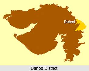
 Dahod district of Gujarat is spread across 7 talukas and Dahod taluka is the district headquarters. The total area of the place is 3,733 sq. km. As per 2001 census the total population of the district is 1.63 Million with 438 Persons per sq. km. Dahod district is the second largest wholesale grains market in Gujarat. The major tourist destinations of the district are Chhab Lake, Aurangzeb`s Fort, Ratanmahal Sanctuary, the Shiva Temple at Bavka, etc.
Geography of Dahod District
Dahod district shares its border with Rajasthan state in the north and Madhya Pradesh state in the east. Geographical location of the place is 20.30 degree to 23.30 degree North (Latitude) and 73.15 degree to 74.30 degree East (Longitude). Average rainfall is 1107 mm and the major rivers of this place are Anas, Panam, Macchan and Kali.
Education in Dahod District
Dahod district has total 1,689 primary, secondary and higher secondary schools (including government and private). Government Engineering College at Dahod offer courses in chemical, civil, electrical, and electronic and communication, information technology, production and mechanical engineering. Government Polytechnic College at Dahod offer courses in computer, electrical, mechanical and civil engineering. The Industrial Training Institutes (ITIs) in the district offer specialised courses such as welding, software programming, electronic system maintenance, mechanics, instrumentation, cutting and sewing to provide trained manpower for the industries.
Economy of Dahod District
Dahod district is predominantly an agricultural region and the prime share of revenue in the district comes from agriculture-based products. The chief products of the district are wheat and maize. Agriculture has given a great impetus to home-based industries such as making jute ropes and weaving bamboo. There are 2,221 units of small scale industries in Dahod providing employment to almost 5,000 persons. Major SSIs in the district are in the sectors such as rubber and plastic products, minerals, food products, engineering, readymade garments, etc.
Tourism in Dahod District
Dahod district has a lot to offer when it comes to tourism. Aurangzeb Fort was built by Mughal Emperor Shah Jahan as a resting place for travellers in honour of his son`s birth. At present it houses government offices and a few dargahs. A Shiva Temple belonging to the 12th century is present in Dahod district. Chhab Talav (Lake) is an attractive destination for the tourists with well developed surrounding area and many food joints. Ratanmahal Sanctuary in Dahod is best known for its Sloth bear conservation and other inhabitants of sanctuary i.e. jungle cats, foxes, porcupines, birds, and reptiles.
How to reach Dahod District
By Road:
National Highway (NH) 59 passes through Dahod and connects it to Ahmedabad (196 km), Godhra (71km) and Indore (249 km). NH 8E (extension) connects Dahod, Zalod, and the Rajasthan border. State highway (SH) 2 connects the district to Ahmedabad and State highway (SH) 12 connects the district to Jambuva in Madhya Pradesh.
By Rail:
The broad gauge railway line connects Dahod to Vadodara, Godhra, Anand, Ahmedabad, and to Ratlam in Madhya Pradesh. There are three railway lines in the district located at talukas, Dahod, Limkheda and Piplod.


