 Geography of East Kameng district exhibits great variations. The district is located at the western part of the state of Arunachal Pradesh. It is situated at the eastern end of West Kameng district. It lies between 920 36` to 930 24` East longitude and 260 56` to 270 59` North latitude. Papum Pare district along with certain parts of Kurung Kumey district surrounds the eastern part of the district whereas Sonitpur district of Assam surrounds its southern part. In the west, the district is bordered by West Kameng district and its northern part is surrounded by a part of Kurung Kumey district and Mac Mohan line. Geographically, the district occupies an area of 4,134 square kilometres.
Topography of East Kameng District
Mountains and deep gorges form the inter district barriers. East Kameng district has also a number of narrow valleys that gradually open up into wide ones. Agriculture is permanently practiced in this region. The district acts as an extension of north east India towards Himalayan ranges.
Rivers of East Kameng District
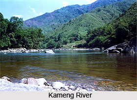
The name of the erstwhile district Kameng was derived from a tributary of the mighty river Bramahputra, named Kameng River. The river originates from the glacial lakes situated below "Gorichan". It flows through East Kameng district and reaches to the plain of Assam. In the Sonitpur district of Assam, the river once again joins the Bramahputra River. Other significant rivers of East Kameng district include Pakke (I), Pakke (II), Papu-Para, Bishom, Pachuk, Pachi, Pacha and Dibru. They all are the tributaries of Kameng River and are not navigable.
Climate of East Kameng District
The district of East Kameng has a variety of topography which causes substantial differences in the climatic conditions of different region of the district. Even within short distances, the climate greatly varies. Various administrative centres of the districts possess different altitudes ranging from 363 metres to 1906 metres. In the northern part of the district arid climate is prevalent in its tundra region whereas cool temperate and humid subtropical climate is found in the southern region which comprises sub-Himalayan hills. During summers, the district receives abundant rainfall whereas during winters it experiences extreme cold. Due to heavy rainfall during monsoons, most of the streams and rivers of the district gets flooded, which often hamper the transportation and communication systems of the district. Frequent landslides are also evident in East Kameng district which makes the maintenance of roadways quite expensive. Owing to this, a number of developmental activities are also held during the monsoons. Intensified developmental work can be observed between the months of October and March.


