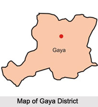
 Gaya district is the 38th among the Indian districts. It is regarded as one of the most sacred place in eastern India.
Location of Gaya District
Gaya District is located in the Eastern Indian state of Bihar and shares a common boundary with the state of Jharkhand. Gaya is Bihar`s second largest city.
History of Gaya District
The name of Gaya has appeared in Hindu epics like Mahabharata and Ramayana. Hindu mythology has asserted that Lord Rama had paid a visit to this district, along with his brother Laxman to offer `pind-daan` to King Dasaratha, their father. His wife Sita also accompanied him. This place had been demarcated as Gayapuri in Mahabharata. Gaya has witnessed the regime of several important dynasties like those of Magadhas in the 6th century to the 18th century AD, the Sisunaga dynasty who controlled Gaya about 600 BC., King Bimbisara who ruled this place around the period of 519 BC, the Nanda dynasty and Mauryan dynasty who exercised power over the region of Gaya. During the 12th century, Gaya came under the rule of Muhammad Bakhtiyar Khilji after being annexed by the Muslim ruler. Finally, Britishers captured Gaya following the Battle of Buxar in the year 1764. Gaya received independence in 1947, from the British Raj. Gaya continued to be a portion of the districts of Ramgarh and Behar till the year 1864. In 1865, Gaya attained the status of an independent Indian district. The Bihar Government created the Magadha Division in May 1981. Presently, Gaya is part of the Red Corridor.
Geography of Gaya District
 Gaya District measures about 4, 976 square kilometres. Phalgu River flows through this Indian district. The Gautama Buddha Wildlife Sanctuary was created in Gaya in the year 1976 and it occupies an area of nearly 260 square kilometres.
Demography of Gaya District
The 2011 census states that Gaya district possesses a population of about 4, 379, 383, which has helped it to receive a ranking of being the 42nd in the country. The rate of population growth rate of this district is approximately 26.08% over years 2011 to 2011. The literacy rate of Gaya is 66.35%. There are 932 females for every 1000 males in Gaya district.
Education in Gaya District
Gaya consists of numerous educational institutions like schools and colleges which impart excellent quality of education. The various boards are ICSE, CBSE and many others. Hadi Hashmi High School, Mahavir School, Zila School, Qasmi High School, Agrawal high School are a few of the schools which are affiliated to the Bihar School Examination Board in Gaya. Creane Memorial School, Kendriya Vidyalaya, Nazareth Academy, DAV Rotary Campus and others are governed by the ICSE CBSE boards of education. The Union Government of Gaya has set up two central universities known as Central University of Bihar and another academic institution. Courses involving undergraduate and master degree programmes are organised in the colleges and local universities of Gaya.
Economy of Gaya District
The Ministry of Panchayati Raj had named Gaya as one of India`s 250 most backward districts in the year 2006. This district is presently functioning with the aide of funds financed by the Backward Regions Grant Fund Programme (BRGF).
Tourism in Gaya District
Gaya District has many tourist delights like Parashnath Hills, Rajgir, Bodhi tree, Mahabodhi Temple, Thailand Monastery, Pragbodhi Cave, Sujata Garh and the 80 feet large statue of Gautama Buddha.


