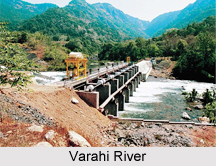
 Varahi River is a costal river located in the Indian state of Karnataka. More specifically, it flows through Western Ghats in Karnataka. This river is known by the name of Halady River. In mythological texts, the term Varaha is mentioned in the context of Lord Vishnu. Varaha is one of the incarnations of Lord Vishnu whereas Varahi is the feminine gender of Varaha. Characteristically, this river is known to be swift and powerful.
Geography of Varahi River
Globally, Varahi River can be pinpointed at coordinates 13 degrees 40 minutes 21 seconds North and 75 degrees 4 minutes 36 seconds East. This river originates at an elevation of about 730 metres (2,400 ft) above mean sea level. The annual rainfall received by this river varies from 20 to 1,280 centimeters (7.9-503.9 in).
Course of Varahi River
The place of origin for Varahi River is Western Ghats. More specifically, Hebbagilu near Agumbe in Thirthahalli taluk in the district of Shivamogga is the source of Varahi River. This river flows through Western Ghats towards Arabian Sea. It even journeys through Halady, Basrur, Kundapur and Gungulli and then amalgamates with the Arabian Sea near Kundapura in the district of Udupi in Karnataka. Along its course, this river joins the Kedaka River, Chakra River, Souparnika River and Kubja River. The river itself is joined by many tributaries, specifically at places such as Shettykoppa.
Kunchikal Falls formed by Varahi River
After covering a distance of about 25 Kilometres, the Varahi takes a fall of about 455 metres in cascades thus forming the Kunchikal falls. It is located about 25 kilometres (16 mi) from the origin of the Varahi River in Hosanagara Taluk in Shimoga. The falls do not take place directly, but are characterized by a jump making its way through rocks and boulders. Mani Dam"s construction across the Varahi River acted as a barrier for the flow of water in these falls. Thus, with considerable reduction in the water flow these falls are functional only during the rainy seasons.
Development of Varahi River
Under the Varahi Hydro-electric Project, a hydroelectric dam was planned to be constructed across the Varahi River. This dam is called Mani Dam. Its name is derived from the name of a village called Manibail. It is located across the Varahi River, near Yadur, near Masthikatte in Shimoga District. Water from Mani dam passes through a pick-up dam. This water is the source for generation of power. There are two generating units with a capacity of 4.5 MW at the Mani Dam site. This dam proved to a blessing for many villages in the vicinity. Varahi lift irrigation project, using the waters of Varahi River is being constructed since 1979 near Siddapura village of Udupi district.
A powerhouse is also built against Varahi River under the Varahi Hydro-electric Project. Varahi is known to be Karnataka"s first underground powerhouse. It is also considered to be a key milestone in the corporation history of Karnataka Power Corporation Limited (KPCL). At the blueprint stage, a surface power house was planned to be constructed. However, based on three key grounds, an underground powerhouse became the reality. The project officials were concerned about the protection of environment, technical and economic factors which compelled them to situate the power house underground. This underground power station uses water from Varahi River near Hosangadi in Udupi district. This project will generate power only during the morning and evening peak duration of about eight hours a day. The production of electric power under this project commenced at a time when the State"s power shortage was expected to increase during summer. This project is divided into stage-1 and stage-2 and both the stages are part of an underground powerhouse. Under Stage-1 of the project, there are two generating units with a capacity of 115 MW each. The Stage II was expected to save Rs. 1.25 crore a day for the State as it generated power at a low cost. Thus, Karnataka could buy power from private power producers at a high cost. This stage is known to have a total installed capacity of 230 MW, contributing 1100 MU annually. This consists of 4 x 115 MW Generating Units at Varahi underground powerhouse.
Related Articles:
Indian Rivers
Tungabhadra River
Kaveri River
Krishna River
Sharavati River
Malaprabha River
Kabini River
Bhadra River
Tunga River
Netravati River


