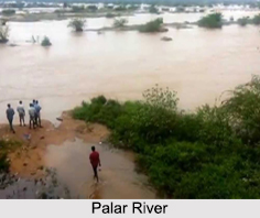
 Rising in the Nandi Hills of the Chikkaballapura district in the state of Karnataka, the Palar River is a part of southern India and flows for a total length of 348 km. There are various reservoirs and check dams across the river to store the water, and out of these two of the most significant dams are that of Bethamangala and Ramasagara.
Water from the Palar River is diverted to the Poondi reservoir on the Kosasthalaiyar River basin and the Chembarambakkam Lake on the Adyar River basin. These two reservoirs used to be one of the primary sources of water supply to the Chennai city.
Course of Palar River
The Palar River flows 93 km in Karnataka, 33 km in Andhra Pradesh and 222 km in Tamil Nadu before finally reaching its confluence in Bay of Bengal at Vayalur about 100 km from south of Chennai. The Palar River flows as an underground river for a long distance and emerges near Bethamangala town, from where it gathers speed and flows eastward down the Deccan Plateau. The cities of Ramanaickenpet, Vaniyambadi, Ambur, Vellore, Melvisharam, Arcot, Walajapet (Anaicut), Kanchipuram, and Chingleput are located on banks of Palar River. Out of the seven tributaries and the chief tributary of Palar is the Cheyyar River.
In 2015, the residents of Vellore witnessed the Palar River come to life after almost a decade long dry spell and recently in Pullur, Tamil Nadu, after 20 years the river has come to life due to heavy rainfall.
Climate around Palar River
The average rainfall in the entire Palar river basin is low. This river basin used to suffer from frequent droughts. However, Karnataka and Tamil Nadu have mitigated frequent recurrence of droughts by developing innumerable minor and medium irrigation tanks. This has improved the availability of water for surface as well as ground water irrigations. As per the wet land atlas of India, the manmade wet lands are covering extensive area about 3 percent to 5 percent in the districts of Karnataka and Tamil Nadu covering Palar river basin. The Palar basin in Andhra Pradesh is not well covered by wet lands, which implies that the river water usage in Andhra Pradesh is not up to the mark, compared to Karnataka and Tamil Nadu.
Places of Attraction around Palar River
The most visited and popular places of attraction in and around Palar River are the temples. The Venugopalaswami Temple in the Kanchipuram district of Tamil Nadu is a historic temple located on the banks of the river. Other known important temples on the bank of the Palar River are the Vijayendra Swamy Temple in Bethamangala, Channakeshava Swamy temple, Someshwara Swamy Temple and Veerabadra Swamy Temple in Ramasagara.


