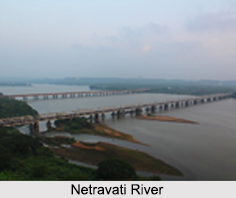
 The Netravati River originated from the Indian state of Karnataka. More specifically, this river has its origin in the Chikkamagaluru district of Karnataka at Bangrabalige valley, Yelaneeru Ghat in Kudremukh. Also known as Nethravathi, the Netravati River is a major source of water to Bantwal and Mangalore. The town of Bantwal was located on its banks and thus the Netravati River was called the Bantwal River in the last century.
The Netravati River is amongst the sacred rivers of India. As per the Gazetteer of Southern India published in 1855, it referred to the river as unaffordable during the south-west monsoon. Under the world"s biodiversity conservation project, the catchment area of Netravati River is selected as one of the 30 hotspots for biodiversity conservation.
Geography of Netravati River
With a drainage area of about 1,353 square miles, the Netravati River has an apparent breadth of almost 200 yards. The river bed mainly comprises of hornblende rock containing spangles of mica and small garnets, which act to fetter the river bed. Apart from these large rocky masses, the smooth river bed also has sienites occurring in the form of fragments of a beautiful pegmatite with flesh coloured feldspar.
A railway bridge was constructed on the Netravati River which served as one of the major gateways to Mangalore. Netravati River"s railway bridge is considered to be the longest railway bridge built atop a river bank. The nearby cities of Netravati River are Bangady, Ishaq Indabettu and Nellyady Town.
Course of Netravati River
The Netravati River originates in the Western Ghats in the Bangrabalike forest Valley of Yellaner Ghats of the Kudremukha range in Karnataka. The river merges with the Kumaradhara River, which also originates in Western Ghats in the Subramanya range near Uppinangadi village.
Netravati flows from Uppinangadi and enters the city of Mangalore, where it then joins the Arabian Sea. Estimated records suggest that the Netravati River drains more than 100 TMC of water into the Arabian Sea every year. Along its course, the Netravati also flows through the popular pilgrim place called Dharmasthala. The navigability of the Netravati River is dependent on small country craft, which has the potential to travel many miles in the river.
Tributaries of Netravati River
The Netravati River branches out into several tributaries. These tributaries have blessed the area around with greenery which is evident throughout the year. Also, water from the tributaries like Hemavati, Cauvery and many others is utilized for irrigation purposes. These tributaries drain surplus water into the streams, small rivers and rivulets thereby keeping the hydro-system of the Western Ghats active.
Floods caused by Netravati River
During the monsoon season, the Netravati River overflows, this has an adverse effect on the nearby areas. In the past years, the Bantwal taluk in the Dakshina Kannada district of Karnataka has often been submerged during the monsoon. According to the locals of the town, 1928 and 1974 were the years when major floods had conquered Bantwal.
Livelihood on Netravati River
The Netravati River functions to serve as the main water resource to Mangalore and Bantwal. A total of 38 reservoirs are formed by ancillaries that are spread over the region. It has been estimated that over 40 lakhs people are dependent on the waters of the Netravati River to meet their daily requirements. Undoubtedly, people inhabiting the area near the banks of river are involved in agriculture and farming.
The marine life of this river is valuable for fishing. As estimated, 7 lakhs farmers have grown paddy fields on the 35,000 hectares of land near Netravati River. Also, the bed of the river serves as the source of sand, which is characteristically smooth. This sand is further utilized for construction purposes.
Ecological Crisis Faced by Netravati River
The ecologically fragile Netravati River is facing threats by many mini hydroelectric projects and a diversion project. Some of these have been executed while others are still in their planning stages. The Netravati River Diversion Project, also termed as Yettinahole project was aimed at the diversion of the Netravati River to eastern parts of Karnataka, thereby supplying water to the water-starved districts of Hassan, rural Bengaluru and Chikaballapur.
This project would divert more than 24 TMC. ft of water from Netravati to its surrounding dry districts at an estimated cost of more than Rs.8, 000 crores. But experts did not consider this plan to be viable. According to their analysis and estimation, the river is a living thing and its movement to another direction will impact the environment as it is against the nature"s laws. More specifically, the marine life of the river may be endangered, due to the reduction in the amount of freshwater outflow and the resultant decline of nutrients flowing into the sea.
Deliberate changes in the course of the river may also adversely affect the contiguity of rainforests in Western Ghats. Fortunately, some opposition was raised against hydro electric projects on Netravati River, but Yettinahole project could not be stopped from being executed. On March 3, 2014, Karnataka Chief Minister K. Siddaramaiah had laid the foundation stone of this project despite the widespread protests by the locals and Dakshina Kannada industry bodies.


