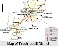
 Tiruchirapalli district is located centrally in the state of Tamil Nadu and possesses a geographical area of 4, 40,383 hectares. The district of Tiruchirapalli is situated in between ten degree and eleven degree thirty minutes to the North latitudes and between seventy seven degree forty five minutes and seventy eight degree fifty minutes to the East longitudes. The maximum temperature experienced in this district is 37.7 degree Celsius and the minimum temperature is 18.9 degree Celsius. The net area cropped in Tiruchirapalli district is 1, 85,193 hectares and out of which about 102799 hectares are irrigated and about 82394 hectares are rain fed. Kaveri River irrigates about fifty one thousand hectares in Trichy, Lalgudi and Musiri divisions. The normal annual rainfall is 842.60 millimetre. Multi various crops are grown in this district and agriculture forms the main occupation for most of the people of the district of Tiruchirapalli.
History of Tiruchirapalli District
The district`s history dates back to 300 BC when Woraiyur formed the capital city of the Cholas which is also evident from the archaeological findings and ancient literatures. Woraiyur is a part of the present day district of Tiruchirapalli. There are also literary sources which state that Woraiyur continued to be under the control of Cholas even during the days of Kalabhra interregnum from A.D. 300 to A.D. 575. The district of Tiruchirapalli witnessed the rule of the Pallavas, the Pandyas, the Cholas, the Hoysalas, the Vijayanagar rulers, the Mughals and also the British.
 Education in Tiruchirapalli District
The district of Tiruchirapalli has several educational institutions. There are about twenty two arts and science colleges, one medical college, about ten engineering colleges, one college for agriculture, one law college and one college for special education. For school education, there are about one thousand fifty four primary schools, about two hundred and seventy three middle schools, about eighty nine high schools, about one hundred and twenty one higher secondary schools and about five teacher training colleges.
Tourism in Tiruchirapalli District
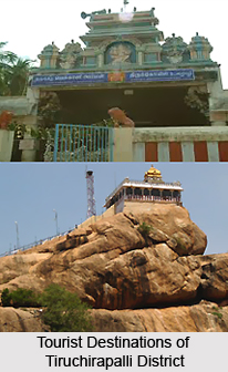
The district of Tiruchirapalli possesses a number of tourist attractions which draw a large number of tourists through out the year. Mosques, temples, historical buildings and picturesque natural beauty define the South Indian beauty of nature and human magnificence. Tourism in Tiruchirapalli or Trichy has got a name due to its scattered natural beauty. Due to the huge industrial growth, the district is a thriving commercial centre in the state of Tamil Nadu and is well-known for artificial diamonds, handloom cloth, cigars, glass bangles and wooden and clay toys. The district of Tiruchirapalli is situated three hundred and twenty kilometres from Chennai and lies on the banks of the Kaveri River. Some of the most famous attractions in the district are Grand Anaicut, Vekkaliamman Kovil, Samayapuram, Puliancholai, Vayalore, Mukkombu, St. Lourdu`s Church, Hazrath Nathervali, Jambukeswara Temple, Rockfort, Srirangam, etc. The temples of Tiruchirapalli district attract a large number of tourists from various parts of the state as well as from outside.
The Tiruchirapalli district covers an area of 4,403.83 square kilometers. The area under cultivation in this district is 1, 85,750 hectares. Some of the major crops grown in this district are rice, pulses, millets and other cereals, groundnut, sugarcane, cotton, gingelly, etc. Sericulture was introduced in Tiruchirappalli District in the late 70`s and the progress is slowly picking up. At present, it has got mulberry cultivation which is about 217.00 acres involving about three hundred and eight sericulturists in silkworm rearing.


