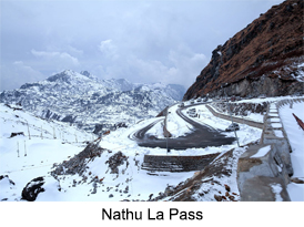
 Nathu La Pass is one of the major passes in India that was built to connect the Indian state of Sikkim with Tibet. This is one of the ancient routes which was used as the Silk Route in ancient days. Built at an altitude of 4,310 m or (14,140 ft), it is one of the three trading routes that is located at the border of India and China. While the other two are Shipkils at Himachal Pradesh and Lipulech in Uttarakhand, Nathu La is one of the most important passes which was re-opened in 2006 following numerous bilateral trade agreements. This is a major pass which was opened with an expectation to improve trade relations between India and China which shall give impetus to Sino-Indian trade relations. Also the route shall reduce the travelling distance between the well known Hindu and Buddhist pilgrimage centres.
History of Nathu La Pass
Historically, Nathu La Pass is an offshoot of the Old Silk Route which stretches up to 563 kms. The old silk route connects Lhasa in Tibet with the plains of West Bengal in India. The significance of this route was realised in 1873 after which Nathu La played a key role in 1903-1904 during the British expedition to Tibet. In 1904, Major Francis Younghusband, the commissioner to Tibet led a successful expedition through this pass to capture Lhasa. This led to setting up of a number of important trading posts in Tibet by the British Empire. Later on, in 1947-48 Sikkim has a new option of joining the newly independent India. On this, Sikkim agreed to be a protectorate of India under which India was allowed to man the borders. Since then Nathu La Pass played a major role between India and China. Nathu
La Pass was a major corridor of passage between India and Tibet before it was closed in 1962.
Geography of Nathu La Pass
Nathu La Pass is located at a distance of 54 kms from Gangtok, the capital of Sikkim and 430 kms from Lhasa, the capital of Tibet. It is one of the highest motorable roads in the world and is richly surrounded by alpine flora. During winters the pass is covered with snow. Nathula has moderately shallow, drained, coarse, loamy soil on a steep slope which has a number of sinking zones with a lot of depressions which are prone to landslides. Because of its difficult terrain the place is maintained by the Indian Army.
Flora and Fauna of Nathu La Pass
Nathu La Pass is also known for the flora and fauna. Because of its elevation, the region is largely covered with sub tropical forests and shrubs which are scattered over the region. Along with some major species of dwarf rhododendrons, junipers and medicinal herbs are found. The region has some animals like nomadic Tibetan graziers or Dokpas herd yak, sheep and goats which are found in this region. Also some endangered species like Tibetan gazelle, snow leopard, Tibetan wolf, Tibetan snow cock, lammergeier, raven, golden eagle and ruddy shelduck are found in this region. Among the Avifauna; Blue Whistling-thrush, redstarts and fork tails are found near waterfalls and hill-streams. Also mixed hunting species like warblers, tit-babblers, tree creepers, white-eyes, wrens and rosefinches along with Raptors such as black eagle, black-winged kite and kestrels; and pheasants such as monals and blood pheasant are found in this region.
Economy of Nathu La Pass
Economically, Nathu La mainly depends on the trade relations which were built through the pass. Till 1962 sealed, goods such as pens, watches, cereals, cotton cloth, edible oils, soaps, building materials, and dismantled scooters and four-wheelers were exported to Tibet through the pass on mule-back. On a return silk, raw wool, musk pods, medicinal plants, country liquor, precious stones, gold and silverware were imported into India. To expand cross-border trade, the two countries have set up trading marts at Sherathang in Sikkim which is 6kms from Nathu La and Rinqingang in Tibet that is 10 km from Nathu La. About 100 traders along with 60 trucks were allowed to pass the border and continue trade across the border.


