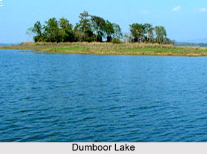
 Dumboor Lake is at a distance of 120kms from Agartala. Dumboor Lake is situated amidst picturesque hills covered with natural vegetation. It covers an area of 41 sq km of water surface and possesses nearly 48 islands. Dumboor Lake is surrounded by weeds and sand. The area grows into lush greenery through the winter and monsoon season. With its enriched ecology this place often attracts the migratory birds that fly over this region. Along with migratory birds the place has a rich water reservoir which has wide collection of fishes breeding in the natural environment of the lake.
Dumboor Lake is a charming water body located in Amarpur Sub Division 120 Km. away from Agartala. The look of the lake is like tabour shaped small drum, "Dumboor" of Lord Shiva from which the name "Dumboor" originates.
Dumboor Lake does not have any boundary. Being at a distance from the city lights, a number of Migratory Birds flock here in the winter season. Dumboor Lake is one of the best places for Bird Watching. Various species of migratory birds are visible in the winter and it has rich reservoir of natural and cultured fishes. Water sports facilities are additional attraction. There is a major Hydel Project near the lake from where River Gomati originates and this is called Tirthamukh where on 14th January every year famous "Pous Sankranti Mela" takes place. The lake is the confluence of rivers Raima and Sarma.
Situated amidst picturesque hills packed with vegetation, the Dumboor Lake is a perfect holiday destination to take a tour; it is one of the major attractions of Tripura, India. The lake also acquires a rich reservoir of natural and cultured fishes.
Thus Dumboor Lake is not only an important tourist spot but also it is used for the Hydel project of the state. Dumboor Lake is situated about 58kms from Udaipur City. It connects of the three most important destinations - Agartala, Udaipur and Gomti River.
Nearby Tourist Destinations around Dumboor Lake:
•Rudrasagar Lake: Located 55km away from Agartala, is the Rudrasagar Lake. The famous Palace of Agartala Neer Mahal is located in the centre of the Rudrasagar Lake.
•Kamala Sagar Lake: Kamala Sagar Lake was excavated Maharaja Dhanya Manikya in the 15th Century. Near the bank of Kamala Sagar Lake, there is the beautiful Temple of Goddess Kali. It also makes for a good picnic spot.
•Khowra Lake: Khowra Lake is famous for the Shivasthali. Twice every year, fairs are held in the Shivasthali. Thousands of people come here to get the blessings of the God. Some of the water sports are also available in the lake. Boating is best thing here.
Journey to the Dumboor Lake
Nearest airport is at Agartala. The Agartala airport connects Tripura to the rest of India by air. The nearest rail station is at Kumarghat. From here you can reach the place by road. The Lake is about 110kms away from Agartala. One can travel by buses, private taxies and rickshaws from here to reach the lake.


