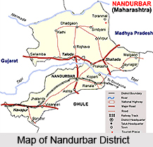
 Nandurbar District is an administrative district of Maharashtra. Nandurbar is the district headquarters. Nandurbar District is located between 21 degree to 22 degree 3 minutes north latitude and 73 degree 31 minutes to 74 degree 32 minutes east longitude. Nandurbar District is bounded to the south and south-east by Dhule district, to the west and north by the state of Gujarat, to the north and north-east is the state of Madhya Pradesh. The northern boundary of Nandurbar District is bounded by the Narmada River. Total geographic area of Nandurbar District is 5034 sq kms.
History of Nandurbar District
Before 1st of July, 1998 Nandurbar was part of the larger Dhule District. Nandurbar, Dhule District and Jalgaon District formed what was known as the Khandesh district. Dhule was known as the west Khandesh whereas Jalgaon was known as the east Khandesh. So, the history of Nandurbar District is similar to the history of Khandesh and Dhule. History states that prior to 1906 Dhule, Nandurbar and Jalgaon district were together known as Khandesh. According to some legends, Khandesh means the country of Lord Krishna. In the year 1906 from administrative point of view Khandesh district was bifurcated in two districts namely East Khandesh and West Khandesh. Later on the names of East Khandesh and West Khandesh district have been changed as Jalgaon and Dhule District respectively. Further on 1st of July 1998, Dhule District was bifurcated in two districts namely Dhule and Nandurbar. Nandurbar is also known as Nandanagri as the king Nandaraja was the ruler of this territory.
Geography of Nandurbar District
The climate of Nandurbar District is generally hot and dry. Summer is from March to mid of June. Summer season is usually hot and dry. During the month of May the summer is at its peak. Temperatures can be as high as 45 degree Celsius during the peak of summer season. The monsoon sets in during the mid or end of June. During this season the weather is usually humid and hot. The northern and western regions receive more rainfall than the rest of the region. The average rainfall is 859 mm in the district. Winters are mildly cold but dry. Narmada River and Tapi River are the two main rivers flowing through Nandurbar District.
Demography of Nandurbar District
As per 2001 Census, Total population of Nandurbar District is 1,311,709, out of which male population is around 50.62 percent and female population percentage is 49.38 percent. Nandurbar District has an average literacy rate of 46.63 percent, male literacy is 55.11 percent and female literacy is 37.93 percent. Ahirani, Bhili language, Pardhi, Marathi language, Hindi language and Gujari are the main languages spoken in Nandurbar District. Agriculture is the main source of economy of the district. Main crops cultivated here are Jowar, wheat, rice, and Groundnuts. Annual cash crops are sugarcane and cotton.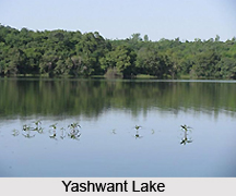
Administration of Nandurbar District
Administration of Nandurbar District comprises six talukas. These talukas are Akkalkuwa, Akrani Mahal (also called Dhadgaon), Taloda, Shahada, Nandurbar and Navapur. Further, there is one Lok Sabha constituency in Nandurbar District which is Nandurbar reserved for ST. There are four Maharashtra Assembly seats namely Akkalkuwa (ST), Shahada (ST), Nandurbar (ST) and Nawapur (ST). Sakri (ST) and Shirpur (ST) assembly seats from Dhule District are also part of Nandurbar Lok Sabha seat.
Tourism in Nandurbar District
There are several places of tourist importance in Nandurbar District. Prakasha, one of the famous religious places, also known as Dakshin Kashi, is in Shahada tehsil. There is one temple at Jaynagar, 24 km away from Shahada and is dedicated to Lord Ganesha. Thousands of people visit this temple on the occasion of Mangli Chaturthi. Asthamba Rishi Yatra in Akrani tehsil religious places is also in this district. Toranmal is the second coolest hill station in Maharashtra state and is near Shahada. It is the second highest place in Maharashtra. Flanked by the 7 hills of the Satpura mountain range, Toranmal nestles among varieties of flora and fauna. It has a natural lake called Yashwant Lake.
Nandurbar District is also known for its unique and distinct tribal culture.


