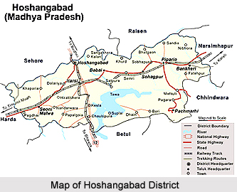
 Hoshangabad District, an administrative district of Madhya Pradesh, has its administrative headquarters located at Hoshangabad town. It takes its own name from the head quarters town Hoshangabad which was founded by `Sultan Hoshang Shah Gori`, the second king of Mandu (Malwa) in early 15th century. The total area occupied by Hoshangabad District is 5408.23 sq kms. The average height of Hoshangabad District from the sea level is 331 metres.
Hoshangabad District lies in the central Narmada River Valley and on the northern fringe of the Satpura Mountain Range. It lies between the parallels of 22 degree 15 minute and 22 degree 44 minute east. The northern boundary of Hoshangabad District is Narmada River. Across this district lie the Raisen District and Sehore District. Betul District lies in the south of Hoshangabad District, where as the Harda district faces with the western and southwestern boundaries and Narsinghpur District and Chhindwara district, close to the northeastern and southeastern sides of the district respectively.
Geography of Hoshangabad District
Hoshangabad District is an irregular strip elongated shape along the southern banks of the Narmada River. Its greatest length from southeast to northeast is 160 kilometres. In Hoshangabad District, there are two main rivers namely the Narmada and Tawa River, which join each other at the village Bandra Bhan. On Kartik Purnima, several fairs are organised in this village. Other small rivers are the Dudhi River and the Denwa River. The climate of Hoshangabad District is moderate type of climate. It includes four main seasons like the summer season, winter season, monsoon and post monsoon season. Average annual rainfall in the district is 134 centimetres. The average maximum and minimum temperatures recorded in the district are 32 degree Celsius in the hot weather seasons and 19 degree Celsius in the cold winter seasons. Overall, the climate of the district is pleasant throughout the year.
Demography of Hoshangabad District
According to the Population Census in India in the year 2011, Hoshangabad district had population of 1,240,975. Out of which the male and female were 648,970 and 592,005 respectively. The population of Hoshangabad District constituted 1.71 percent of total population of the Madhya Pradesh. The population density of Hoshangabad district is 185 people per sq. km. The average literacy rate of Hoshangabad in 2011 was 76.52. The male and female literacy rates were 85.17 and 67.04 respectively. The total literates in Hoshangabad District were 826,057, of which the male and female were 480,781 and 345,276 respectively.
Education in Hoshangabad District
In Hoshangabad District, there are around 960 Primary Schools, near about 207 Middle Schools, 69 Senior Secondary Schools and nearly 9 Schools are operated by Tribal Department. Moreover, there are almost 11 Colleges and 1 is Polytechnic College. All the colleges are functioning under Bhopal University, Bhopal. There is no other technical and medical college in the district. In Hoshangabad District, there is one office on Saksharta Programme and many literacy programmes are in-progress under the guidance of Zilla Saksharta Office to literate the people. Out of these 11 colleges, seven are Post Graduate Colleges. Post Graduate courses in Science, Arts, and Commerce are available at these colleges - Narmada Maha Vidyalaya, Home Science College, Mahatma Gandhi Smiriti Maha Vidyalaya, Kusum Mahavidyalaya, Makhanlal Chaturvedi Mahavidyalaya, Shaskiya Kanya Mahavidyalaya, and Shaskiya Snatkottar Mahavidyalaya.
 Tourism in Hoshangabad District
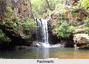
Pachmarhi is a popular hill station in the Satpura mountain range. It is situated in Pipariya tehsil of Hoshangabad District. Pachmarhi is known as the `Queen of Satpura`. It is a regional belief that the name Pachmarhi is a derived from "Panch-Marhi" or the five caves of the Pandavas. During the rule of British East India Company and the British Government, the Pachmarhi was the summer capital of the Central Provinces of British India. There is also a very big lake at Pachmarhi, which is one of the major tourist places of Hoshangabad District. It is opened for boating for the tourists. Other tourist attraction sites are Rajat Prapat, Pandav Caves, Bada Mahadev, Gupt Mahadev, Bee Falls, Chauragarh (The devotees of Lord Shiva come here in huge numbers during the festival of Mahashivratri, Dhupgarh (the highest peak of the Satpuras), Handi Khoh, Apsara Falls or the "Fairy Pool", Jatashankar, Duchess Fall, Pansy Pool, Waters meet, Picadilly Circus, Patharchatta, Crumps Crag, Lady Robertson`s view, Colletin Crag and Mount Rosa. Hoshangabad is well connected by roadways and railways from the state capital, Bhopal and it is about 70 kms away from this town. It is connected by rail with all major cities of the state. One of its tehsils namely Itarsi is linked with all major cities of the country by way of the main railway junction of the central railway, which is 18 kms away from the district headquarters. From Itarsi one can easily reach Pachmarhi by road.


