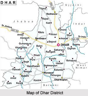
 Dhar District is an administrative district of Madhya Pradesh and has its headquarters located at Dhar town. Dhar District is located at 22 degree to 22 degree 49 minutes north latitude and 75 degree 6 minutes to 75 degree 42 minutes east longitude. Average altitude of Dhar District is 588 metres above sea level. The district extends over three physiographic divisions. Majority of the population in Dhar District belongs to the Scheduled Tribes. The main tribes in the District are Bhil tribe and Bhilala Tribe.
History of Dhar District
History of Dhar District dates back to ancient periods. This region was under the rule several dynasties and rulers before it was annexed to the British East India Company. Dhar District also played a great role in the freedom struggle of the country. The British Government however, changed the decision of Government of India, and restored Dhar to Anand Rao III, in the year 1860. There are several places of historical interest that aptly reflect the rich history of the region. Thousands of tourists are drawn to the various ancient sites of Dhar District to have a glimpse of the splendid movements here. One of the places of great national importance is Bagh, where the caves have been excavated. The paintings at Bagh date back to a period between the 5th and 7th centuries AD, the Golden Age of Indian Art. Together with the paintings of Ajanta, the Bagh paintings represent the finest traditions of Indian Art, which had a far-reaching influence on Buddhist Art in India.
Geography of Dhar District
Geography of Dhar District includes three main topographical divisions and these are Malwa in the north, the Vindhyachal range in central zone and the Narmada valley in the southern boundary. Three main rivers are flowing through the district - Narmada River, Mahi River and Chambal River. Ramayana, Mahabharata and Indian Puranas have references of Narmada River. The Rewa Khand of Vayu Purana and the Rewa Khand of Skanda Purana are entirely devoted to the story of the birth and the importance of Narmada River. According to the Puranas the Narmada is also called the Rewa, for its leaping motion through its rocky bed. In the central parts of India the river is held to be far more sacred than any other stream in India. The river is crossed by roads at Khalghat and Chikhaldara in Dhar District.
Demography of Dhar District
Dhar District had population of 2,184,672 of which male and female were 1,114,267 and 1,070,405 respectevely. This was reported in the population census of 2011. THe data of population in 2011 also shows that the population density of Dhar district is 268 people per square. Kilometers.
Culture of Dhar District
Dhar District is a culturally rich district of Madhya Pradesh. This is mainly a Hindi speaking district. Other languages spoken in the district include Malvi language, Urdu language, Gujarati language, Marathi language and Marwari language. Nimadi language is spoken in the Manawar and Kukshi tehsils bordering West Nimar district. Here, people engage themselves in some form of fine arts such as painting, sculpture, music, dancing, etc. Many of the Bagh cave paintings of the Gupta period have now been destroyed but whatever remains speaks about the high attainment during that period. The construction of magnificent buildings, forts, temples, mosques, etc., during the medieval period at Dhar, Mandu and the surroundings indicate the engagements and amusements of the people of those days. Folk songs and folk dances are also an integral part of the culture of Dhar District. In rural areas, community bhajan singing accompanied with various music instruments is very popular. In Dhar District, several fairs and festivals are organised. Vasant Panchami, Shivaratri, Holi, Ramnavami, Raksha Bandhan, Janmashtami, Ganesh Chaturthi, Dussehra, Diwali, Hanuman Jayanti, Muharram, etc., are celebrated with great religious zeal and enthusiasm by the people. The celebrations of these festivals attract devotees from far and wide.
There are many religious places scattered throughout the district where people congregate at annual fairs arranged on auspicious occasions.


