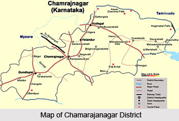
Chamarajanagar District is one of the administrative districts of Karnataka with its headquarters located at Chamarajanagar town. Chamarajanagar District was carved out of Mysore District.
Total area covered by Chamarajanagar District is 5686 sq kms. This district was one of the seven new districts formed on 15th of August, 1997. Those seven districts are Chamarajanagar, Udupi District, Davanagere District, Haveri District, Koppal District, Gadag District and Bagalkot District.
Economy of Chamarajanagar District
Economy of Chamarajanagar District is basically agrarian in character. Agriculture is the backbone of the economy. The main occupation of the people of this district is farming and other allied activities. Most of the lands of the region are dry lands. Since, the irrigation facility is very sparse in the district the farmers are largely dependent on seasonal rains to grow their crops. Maize, jowar, paddy, cowpea, groundnut, cotton, sunflower and sugarcane are the major crops that are grown in the district. The district is traditionally known for Sericulture activities with a total area of 8,601.59 hectares under mulberry cultivation. Coconut, banana, turmeric, and various vegetables are also grown. Sericulture is a traditional activity in Chamarajanagar District.
In terms of number of families engaged in rearing silk worms as also the area under mulberry crops, Chamarajanagar District occupies a prominent place. The district is having around 431 Sericulture villages. The integrated rural cottage industries ancillary to sericulture supports large number of families and provides direct and indirect employment. Average size of sericulture farms in the district is nearly 1.5 to 2 acres.
Chamarajanagar District also has several tourist places that are worth exploring and they attract travellers from all parts of the country.
This article is a stub. You can enrich by adding more information to it. Send your Write Up to content@indianetzone.com


