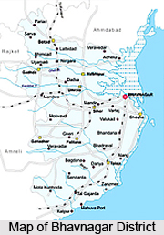
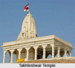
 Bhavnagar district is situated near the Gulf of Cambay in the Arabian Sea, a part of Saurashtra peninsula, in central part of the state of Gujarat. Nearness of this district with commercial districts of Ahmedabad, Rajkot, Surendranagar, and Amreli has made the district an important industrial location. The total area of the district is 8,628 sq. km and as per 2001 census the population is 24, 69,630 with 205 persons per sq km. Major tourist attractions in the district are Velavadar National park-Blackbuck sanctuary, Takhteshwar Temple, Gaurishanker Lake, Jain Temples of Palitana and Talaja.
Geography of Bhavnagar District
Geographical location of Bhavnagar district is 21.47 degree North (Latitude) and 71.15 degree East (Longitude). Average rainfall of the district is 605 mm and the major rivers flowing through this place are Shetrunji, Ranghola and Kaludhar.
Education of Bhavnagar District
Bhavnagar district has a university which offers courses in professional disciplines such as management, computer applications, etc apart from the conventional courses. Bhavnagar hosts a number of Engineering, Medical, Nursing, Ayurvedic, and physiotherapy Colleges and Industrial Training Institutes. Engineering colleges offering courses in chemical, civil, electrical, and electronic and communication, information technology, production and mechanical engineering are present in the district.
Economy of Bhavnagar District
Economical development in Bhavnagar district could be attributed to the presence of a large number of diamond cutting and polishing units, plastics, ship building, salt and marine chemicals, and breaking industries. Bhavnagar stands second in diamond cutting & polishing industry after Surat in India. Bhavnagar is the largest producer of salt, with 34,500 tons of salt being produced annually in the district. Some sections of the society depend upon agriculture for their livelihood. Major crops produced in the district are citrus, onion, guava, banana and chiku. Total production of cotton for the year 2006-07, in Bhavnagar was 12, 73,500 Bales, the second highest in the State after Rajkot.
 Tourism in Bhavnagar District
Bhavnagar district has several places for tourist attraction. Some of the well-known tourist destinations in Bhavnagar are Takhteshwar Temple, Gaurishankar Lake, Gandhi Smriti, Sardar Vallabhbhai Patel (Pill Garden), and old Darbargarh. The Velavadar National Park, which is situated 40 km from Bhavnagar, is a sanctuary for blackbuck, wolf, pelicans, flamingoes, white storks, cranes etc. Talaja is a scenic and peaceful town in the district. Shihor Darbargadh, the royal residence of the Gohil Rajputs between 1570 and 1723 is famous for paintings which depict the attire of the period, the weapons used, and the expressions on the warriors` faces.
How to reach Bhavnagar District
By Road:
National Highway 8E passes through the district connecting it to Junagadh (205 km) and Amreli (113 km). Bhavnagar district is also connected to Ahmedabad (170 km), Vadodara (280 km), Jamnagar (266 km), Surat (447 km), Rajkot (178 km), Ankleshwar (364 km), Vapi (514 km), Gandhinagar (228 km) and Mehsana (274 km).
By Rail:
Almost all the talukas of Bhavnagar are well connected to cities such as Amreli, Ahmedabad and Mumbai by rail.
By Air:
Bhavnagar is one of the first cities to have an airport in Gujarat. Air services are available between Bhavnagar and Mumbai. Nearest international airport is in Ahmedabad (200 km).
By Port:
Bhavnagar port is well connected with a broad gauge railway line. The port is 10 km away from Bhavnagar city which is well connected to Ahmedabad and Mumbai. There is a minor port at Ghogha and ship breaking yard at Alang. The nearest natural port of Pipavav is at a distance of 113 km.


