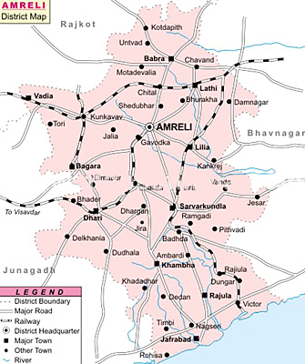
 Amreli district is located in the western part of Gujarat. The district has eleven talukas, of which the major ones are Amreli, Babra, Rajula, Bagasara, Jafrabad, Savarkundla and Vadiya. The total are of the district is 7397 sq km. the district head quarters is at Amreli. Total population of the district is 1.39 million as per 2001 Census. Population density is 188 persons per sq. km. Sex ratio of the place is 987 Females per 1000 Males and the literacy rate 66.10 percent.
Geography of Amreli District
Geographical location of Amreli district is 70.30 degrees to 71.75 degrees East Longitude and 20.45 degrees to 22.25 degrees North Latitude. Average rainfall of the place is 550 mm. Major rivers of Amreli district are Shetrunji, Gagdio, Thebi, Dhatarwadi, Shanti, Vadi and Rayadi.
Education of Amreli District
There are 966 primary, 171 secondary and higher secondary schools present in Amreli district. There is one Government polytechnic college in the district which offers engineering courses in the fields of electronics, mechanical and civil. There are two Pharmacy College and one Management College in the district.
Economy of Amreli District
Amreli district is a base for metallurgical, electrical equipments, cement, ports and ship building industries. Because of the presence of large reserves of limestone, a number of major cement conglomerates, such as Larson and Toubro and Ultra Tech Cement Co. Ltd have established their manufacturing facilities in Amreli district. Outstanding port connectivity with the presence of Pipavav port makes port and ship building industry the chief industry in the district. Maximum numbers of small scale industries are engaged in embroidery products, textiles and wooden boxes.
Agriculture contributes to a great extent to the economy of the state. Major crops being produced in the district are groundnut, cotton, sesame, jowar and bajra. Total agricultural productivity of Amreli district for the year 2006-07 was 1.5 lakhs Metric Tones. The district was the fifth highest producer of oilseeds in the State with a production of 1,305 M.T. in 2006- 07. Total production of cotton in Amreli was 4, 90,100 Bales in 2006-06.
Tourism of Amreli District
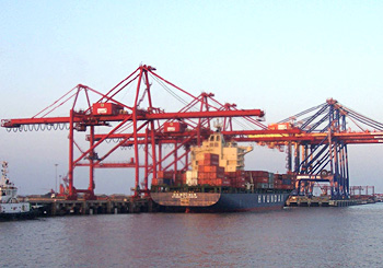 Total forest area present in Amreli district is 30,898 Hectares and it comprise a wide variety of animal and plant species. Amreli also witnessed the presence of Gir National Park; the only abode to Asiatic Lions in the world, in an area of 379.9 sq. km. Shri Girdharbhai Sangrahalaya children`s museum is present in the district, exhibiting art, archaeology, astronomy and natural history. Other renowned places in Amreli are Bhurakhiya Hanuman Mandir and Khodiyar Mandir and Pipavav port.
How to reach Amreli District
By Road: National Highway 8E passes through the district connecting it to Junagadh (92 km) and Bhavnagar (113 km) district. Amreli district is also connected to Ahmedabad (258 km), Vadodara (400 km), Jamnagar (193 km) and Surat (566 km), Rajkot (105 km), Ankaleshwar (483 km), Vapi (633 km), Gandhinagar (358 km) and Mehsana (404 km).
By Rail: Almost all the talukas of Amreli are well connected with the rail network. The total rail length in the district is 271 km. In total there are seven railway stations in Amreli district.
By Air: Nearest airports are in Bhavnagar, Rajkot and Vadodara.
By Port: Nearest ports of the district are in Junagadh and Jamnagar.


