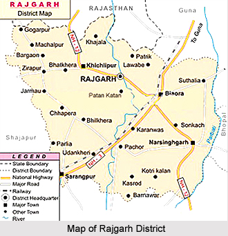
 Rajgarh district is one of the smallest districts in the state of Madhya Pradesh. It is situated in the western parts of the state. The district of Rajgarh shares its borders with the state of Rajasthan, and the Shajapur district, Sehore district and Bhopal district. This district forms the northwestern part of Bhopal Commissioner`s Division. The district has a quadrangular shape with the northern and western sides longer than the southern and eastern sides, respectively. The zigzag boundaries of the district of Rajgarh resemble a pear. Some of the major locations in this district are Zirapur, Biora, Rajgarh, Sarangpur, Khilchipur (Princely State of Khilchipur) and Narsinghgarh (Princely State of Narsinghgarh). Rajgarh is well connected by road railway network.
History of Rajgarh District
Rajgarh district takes its name from the headquarters town Rajgarh that was popularly known as the princely State of Rajgarh. The district of Rajgarh was constituted after the formation of Madhya Bharat in the month of May 1948. Rajgarh was the headquarters of during medieval time, ruled by the Umat Rajputs and branch of the great Paramara Dynasty. They enjoyed a "Sanad" Estate (a legal document approved to the princely state authenticating them in their states, in return for their loyalty) under the Sultans of Delhi and Mughal Emperors in succession. At present, the district is divided into five subdivisions and six tehsils.
Geography of Rajgarh District
Rajgarh district is 390 meters above the mean sea level. The total geographical area of the District is 6,154 square kilometres. It is one of the smallest districts of Madhya Pradesh state, both in respect of area. It is 145 kilometres from the state capital Bhopal. The Newaj River and Parbati River flow through this district. The total area of the district covered by forest is 17,706 hectares and the gross cropped area in this district is 5, 98,200 hectares. The gross area irrigated in the Rajgarh district is 1, 60,096 hectares.
Demography of Rajgarh District
According to the population Census in 2011, Rajgarh had population of 1,546,541 of which male and female were 791,038 and 755,503 respectively. Rajgarh District population constituted 2.13 percent of total population of Madhya Pradesh. The population density of Rajgarh district is 251 people per sq. km. The average literacy rate of Rajgarh in 2011 was 62.68 compared to 53.70 of 2001. The male and female literacy were 75.07 and 49.79 percent respectively.
Tourism of Rajgarh District
One of the most prominent places of tourist interest in the district of Rajgarh is Narsinghgarh. The Narsinghgarh town is about three hundred years old, founded in the year 1681 by Dewan Parasram. The beautiful lake in the town in which is reflected the old fort and palace still bears the name of the founder. The site of the town is the place of the temple of Lord Shiva - then known as Topila Mahadeo, for the persons who lived there manufactured toplis or basket. From the top of the Baijnath Mahadeo temple, the visitor can see the pleasant panorama of nature. Another most beautiful temple is the Jalpamata temple, which is 4 kilometres from Rajgarh. It is on the high hill and one can have a picturesque view of the town from the top. It is covered with dense forest having different varieties of plants. During the Navaratri festival the devotees visit this temple in large numbers. Another major attraction is the Wildlife Sanctuary of Narsinghgarh. Migratory birds from different places visit this Sanctuary. Here in this sanctuary one can have a glimpse of local birds and migratory birds. The national bird, Peacock, is mainly seen in this sanctuary and in nearby areas. Other attractions of this district include Shyamji Sanka temple, Dargah Shareif, Biora Mandu, Khoiry Mahadev temple, etc.


